Category:Kortendijk 6, Vianen
| Object location | | View all coordinates using: OpenStreetMap |
|---|
 | |||||
| Upload media | |||||
| Instance of |
| ||||
|---|---|---|---|---|---|
| Location | Vianen, Vijfheerenlanden, Utrecht, Netherlands | ||||
| Street address |
| ||||
| Located on street |
| ||||
| Heritage designation |
| ||||
 | |||||
|
This is a category about rijksmonument number 37275
|
| Address |
|
Media in category "Kortendijk 6, Vianen"
The following 5 files are in this category, out of 5 total.
-
 Caf‚ interieur - Vianen - 20242028 - RCE.jpg 964 × 1,200; 179 KB
-
 Exterieur voorzijde - Vianen - 20242030 - RCE.jpg 1,200 × 941; 246 KB
-
 Ingang voorgevel - Vianen - 20242029 - RCE.jpg 1,200 × 959; 302 KB
-
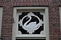 Vianen - Kortendijk 6 - Detail raam - Rijksmonument 37275.JPG 3,872 × 2,592; 3.67 MB
-
 Vianen - Kortendijk 6 - Rijksmonument 37275.JPG 3,872 × 2,592; 3.99 MB


