Category:Kraftwerk Kalsdorf
| Object location | | View all coordinates using: OpenStreetMap |
|---|
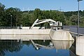
Mur power plant near Gratkorn in Styria  | |||||
| Upload media | |||||
| Instance of | |||||
|---|---|---|---|---|---|
| Location | Kalsdorf bei Graz, Graz-Umgebung District, Styria, Austria | ||||
| Located in or next to body of water | |||||
| Owned by | |||||
| Service entry |
| ||||
| Nominal power capacity |
| ||||
| official website | |||||
 | |||||
Deutsch: Das Kraftwerk Kalsdorf staut die Mur südlich von Graz. Die beiden Kaplan-Rohrturbinen haben eine Leistung von 19 MW. Die Wanderung der Fische ist durch einen Fischaufstieg gewährleistet.
English: The Hydroelectric power station Kalsdorf retains the river Mur in the south of Graz. The two Kaplan bulb turbines are providing an output of 19 MW. The powerplant is equiped with a fish ladder for fish migration.
Media in category "Kraftwerk Kalsdorf"
The following 7 files are in this category, out of 7 total.
-
 Kalsdorf Kraftwerk Fischaufstieg OW.jpg 3,880 × 5,820; 6.36 MB
-
 Kalsdorf Kraftwerk OW Infotafeln.jpg 5,267 × 3,511; 6.34 MB
-
 Kalsdorf Kraftwerk OW Rechenreinigungsmaschine.jpg 5,929 × 3,953; 7.01 MB
-
 Kalsdorf Kraftwerk OW.jpg 5,848 × 3,899; 5.12 MB
-
 Kalsdorf Kraftwerk UW links Rampe.jpg 6,000 × 4,000; 6.69 MB
-
 Kalsdorf Kraftwerk UW links.jpg 5,884 × 3,923; 5.1 MB
-
 Kalsdorf Kraftwerk UW rechts.jpg 5,969 × 3,979; 7.35 MB


