Category:Kraftwerk Wilhelmshaven (E.ON)
| Object location | | View all coordinates using: OpenStreetMap |
|---|
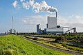
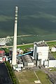
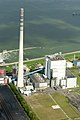
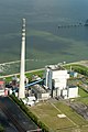
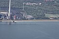
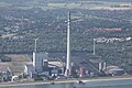
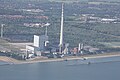
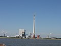
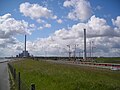
English: A coal power station in Wilhelmshaven, Germany, build in 1976. Do not confuse with the nearby power station built in 2012: Category:Kraftwerk Wilhelmshaven (GDF Suez).
Coal power station in Wilhelmshaven, Germany  | |||||
| Upload media | |||||
| Instance of | |||||
|---|---|---|---|---|---|
| Location | Rüstersieler Groden, Wilhelmshaven, Lower Saxony, Germany | ||||
| Operator | |||||
| Nominal power capacity |
| ||||
| Different from | |||||
 | |||||
Media in category "Kraftwerk Wilhelmshaven (E.ON)"
The following 31 files are in this category, out of 31 total.
-
 2 x Kohleverstromung in Wilhelmshaven.jpg 4,500 × 3,000; 8.82 MB
-
 2012-05-13 Nordsee-Luftbilder DSCF8592.jpg 4,256 × 2,848; 6.14 MB
-
 2012-05-13 Nordsee-Luftbilder DSCF8593.jpg 4,256 × 2,848; 6.28 MB
-
 2012-05-13 Nordsee-Luftbilder DSCF8594.jpg 4,256 × 2,848; 6.81 MB
-
 2012-05-13 Nordsee-Luftbilder DSCF8597.jpg 2,848 × 4,256; 5.55 MB
-
 2012-05-13 Nordsee-Luftbilder DSCF8598.jpg 2,848 × 4,256; 5.89 MB
-
 2012-05-13 Nordsee-Luftbilder DSCF8599.jpg 2,848 × 4,256; 5.87 MB
-
 2012-05-13 Nordsee-Luftbilder DSCF8600.jpg 2,848 × 4,256; 5.69 MB
-
 2012-05-13 Nordsee-Luftbilder DSCF8601.jpg 2,848 × 4,256; 5.73 MB
-
 2012-05-28 Fotoflug Cuxhaven Wilhelmshaven DSC 3909.jpg 2,400 × 1,596; 3.53 MB
-
 2012-05-28 Fotoflug Cuxhaven Wilhelmshaven DSCF9438.jpg 4,256 × 2,848; 7.86 MB
-
 2012-05-28 Fotoflug Cuxhaven Wilhelmshaven DSCF9564.jpg 4,256 × 2,848; 7.11 MB
-
 Flug Wilhelmshaven 2010 099.JPG 2,848 × 4,272; 3.73 MB
-
 Flug Wilhelmshaven 2010 107.JPG 4,272 × 2,848; 4.21 MB
-
 Flug Wilhelmshaven 2010 108.JPG 4,272 × 2,848; 3.69 MB
-
 Flug Wilhelmshaven 2010 109.JPG 4,272 × 2,848; 4.17 MB
-
 Flug Wilhelmshaven 2010 113.JPG 4,272 × 2,848; 3.45 MB
-
 Flug Wilhelmshaven 2010 114.JPG 4,272 × 2,848; 3.66 MB
-
 Jade 47 3223.jpg 5,302 × 3,534; 2.48 MB
-
 Jade 52 A1 1632.jpg 3,737 × 2,491; 1.34 MB
-
 JadeWeserPort, NWO-Ölhafen und Kraftwerke Wilhelmshaven.jpg 4,928 × 3,264; 6.25 MB
-
 Kraftwerk Wilhelmshaven (1976, Uniper).jpg 3,840 × 3,840; 7.48 MB
-
 Kraftwerk-WHV.JPG 2,048 × 1,536; 1.07 MB
-
 Kraftwerk-Wilhelmshaven.JPG 2,048 × 1,536; 605 KB
-
 Kraftwerke Wilhelmshaven.JPG 2,816 × 2,112; 872 KB
-
 Luftaufnahmen Nordseekueste 2013 05 by-RaBoe 559.jpg 2,600 × 1,727; 3.67 MB
-
 Luftaufnahmen Wilhelmshaven (20700831996).jpg 1,800 × 1,200; 1.73 MB
-
 Wilhelmshaven, Germany - panoramio.jpg 2,160 × 3,840; 2.53 MB
-
 Wilhelmshavener Häfen in Niedersachsen.jpg 4,928 × 3,264; 4.92 MB
-
 Wilhelmshavener Häfen, Niedersachsen.jpg 4,928 × 3,264; 6.4 MB
-
 Wilhelmshavener Kraftwerke 5103.JPG 3,187 × 2,207; 1.17 MB


.jpg)


.jpg)


