Category:Labelled administrative maps of Italy
Media in category "Labelled administrative maps of Italy"
The following 14 files are in this category, out of 14 total.
-
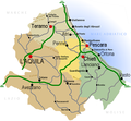 Regione Abruzzo mappa2.png 800 × 738; 222 KB
-
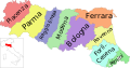 Map of region of Emilia-Romagna, Italy, with provinces-it.svg 4,800 × 2,530; 186 KB
-
 Map of region of Friuli-Venezia Giulia, Italy, with provinces-it.svg 4,316 × 3,831; 102 KB
-
 Unioni territoriali intercomunali del Friuli-Venezia Giulia.png 1,300 × 1,300; 102 KB
-
 Italien Regionen Metropolitanstädte.png 1,830 × 2,177; 135 KB
-
 Map of region of Lombardy, Italy, with provinces-it.svg 5,930 × 5,262; 237 KB
-
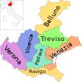 Map of region of Veneto, Italy, with provinces-it.svg 3,346 × 3,385; 170 KB
-
 Map of region of Marche, Italy, with provinces-it.svg 3,504 × 3,450; 114 KB
-
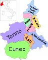 Map of region of Piedmont, Italy, with provinces-it.svg 3,493 × 4,314; 216 KB
-
 Map of region of Apulia, Italy, with provinces-it.svg 4,170 × 3,287; 84 KB
-
 Map of region of Sicily, Italy, with provinces-de.svg 8,803 × 6,748; 137 KB
-
 Map of region of Sicily, Italy, with provinces-it.svg 8,803 × 6,748; 137 KB
-
 Map of region of Tuscany, Italy, with provinces-it.svg 3,624 × 4,010; 228 KB
-
 Map of region of Umbria, Italy, with provinces-it.svg 3,705 × 4,496; 89 KB


