Category:Lake area comparison diagrams
Media in category "Lake area comparison diagrams"
The following 8 files are in this category, out of 8 total.
-

-
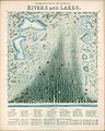 1851 - James Reynolds & John Emslie - Panoramic plan of the principal rivers and lakes.jpg 4,363 × 5,462; 5.23 MB
-

-

-
-

-
 Megachad en disappearance of lake chad.jpg 1,196 × 1,508; 480 KB
-
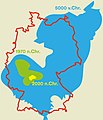 Tschadsee Schrumpfung.jpg 684 × 797; 158 KB
_-_Geographicus_-_MtsRvrsWest-tlls-1850.jpg)


.jpg)

