Category:Landhuis Aardenburg (Doorn)
| Object location | | View all coordinates using: OpenStreetMap |
|---|
building in Utrechtse Heuvelrug, Netherlands  | |||||
| Upload media | |||||
| Instance of | |||||
|---|---|---|---|---|---|
| Part of | |||||
| Location | Doorn, Utrecht, Netherlands | ||||
| Street address |
| ||||
| Located on street | |||||
| Heritage designation |
| ||||
 | |||||
Nederlands: Landhuis Aardenburg
|
This is a category about rijksmonumentcomplex number 508732
|
Landhuis
|
This is a category about rijksmonument number 508733
|
Park
|
This is a category about rijksmonument number 508734
|
| Address |
|
Media in category "Landhuis Aardenburg (Doorn)"
The following 41 files are in this category, out of 41 total.
-
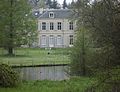
 Aardenburg voorzijde - Doorn - 20059630 - RCE.jpg 1,200 × 809; 249 KB
-
 Doorn - Aardenburg RM508733.JPG 4,389 × 3,354; 3.41 MB
-
 Doorn - Aardenburg, Park RM508734.JPG 4,473 × 3,333; 4.2 MB
-
 Exterieur OVERZICHT VOORGEVEL - Doorn - 20314078 - RCE.jpg 1,185 × 1,200; 477 KB
-
 Huis Aardenburg, exterieur - Doorn - 20059629 - RCE.jpg 1,200 × 770; 328 KB
-
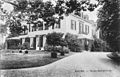
 Huis Aardenburg, exterieur vanuit het zuid-westen - Doorn - 20059592 - RCE.jpg 1,200 × 929; 277 KB
-
 Huis Aardenburg, huis vanuit het noorden 1930 - Doorn - 20059628 - RCE.jpg 1,200 × 876; 238 KB
-
 Huis Aardenburg, oostgevel - Doorn - 20059627 - RCE.jpg 883 × 1,200; 204 KB
-
 Ingang - Doorn - 20369265 - RCE.jpg 1,186 × 1,200; 361 KB
-
 Interieur, begane grond, detail trappenhuis - Doorn - 20369306 - RCE.jpg 1,193 × 1,200; 280 KB
-
 Interieur, begane grond, eetkamer met schouw - Doorn - 20369299 - RCE.jpg 1,185 × 1,200; 243 KB
-

-

-

-
 Interieur, begane grond, kamer links van entree, plafond - Doorn - 20369292 - RCE.jpg 1,190 × 1,200; 251 KB
-
 Interieur, begane grond, kooflijst van de ontvangstsalon - Doorn - 20369291 - RCE.jpg 1,197 × 1,200; 405 KB
-
 Interieur, begane grond, lambrisering ontvangstsalon - Doorn - 20369289 - RCE.jpg 1,195 × 1,200; 385 KB
-
 Interieur, begane grond, ontvangstsalon - Doorn - 20369287 - RCE.jpg 1,185 × 1,200; 274 KB
-
 Interieur, begane grond, ontvangstsalon met schouw - Doorn - 20369288 - RCE.jpg 1,190 × 1,200; 354 KB
-
 Interieur, begane grond, plafond eetkamer - Doorn - 20369300 - RCE.jpg 1,193 × 1,200; 245 KB
-
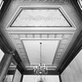
 Interieur, begane grond, plafond in salon - Doorn - 20369285 - RCE.jpg 1,197 × 1,200; 223 KB
-
 Interieur, begane grond, schouw in salon - Doorn - 20369280 - RCE.jpg 1,190 × 1,200; 247 KB
-
 Interieur, begane grond, trappenhuis - Doorn - 20369304 - RCE.jpg 1,190 × 1,200; 269 KB
-
 Interieur, begane grond, trappenhuis - Doorn - 20369305 - RCE.jpg 1,197 × 1,200; 268 KB
-

-

-
 Interieur, kelder onder trappenhuis - Doorn - 20369277 - RCE.jpg 1,190 × 1,200; 260 KB
-
 Interieur, kelder onder trappenhuis - Doorn - 20369278 - RCE.jpg 1,185 × 1,200; 219 KB
-

-

-

-
 Interieur, verdieping, trappenhuis - Doorn - 20369307 - RCE.jpg 1,195 × 1,200; 219 KB
-
 Oostzijde - Doorn - 20369263 - RCE.jpg 1,185 × 1,200; 353 KB
-
 Oostzijde van het park - Doorn - 20369264 - RCE.jpg 1,192 × 1,200; 320 KB
-
 Overzicht voorgevel - Doorn - 20369260 - RCE.jpg 1,188 × 1,200; 312 KB
-
 Parkaanleg, gezicht op eilandje in vijver - Doorn - 20369274 - RCE.jpg 1,185 × 1,200; 467 KB
-
 Parkaanleg, gezicht op vijver - Doorn - 20369273 - RCE.jpg 1,188 × 1,200; 483 KB
-
 Parkaanleg, Zwitserse brug met 'kunstrotsen'op voorgrond - Doorn - 20369276 - RCE.jpg 1,179 × 1,200; 496 KB
-
 Voorgevel - Doorn - 20369268 - RCE.jpg 1,192 × 1,200; 354 KB
-
 Zijgevel - Doorn - 20369267 - RCE.jpg 1,200 × 1,192; 318 KB
-
 Zijgevel zuidzuide - Doorn - 20369266 - RCE.jpg 1,190 × 1,200; 339 KB


