Category:Landscapes of Réunion
Countries of Africa: Algeria · Angola · Benin · Botswana · Burkina Faso · Burundi · Cameroon · Cape Verde · Democratic Republic of the Congo · Republic of the Congo · Djibouti · Egypt‡ · Eritrea · Eswatini · Ethiopia · Gabon · The Gambia · Ghana · Guinea · Guinea-Bissau · Ivory Coast · Kenya · Lesotho · Liberia · Libya · Madagascar · Malawi · Mali · Mauritania · Mauritius · Morocco · Mozambique · Namibia · Niger · Nigeria · Rwanda · São Tomé and Príncipe · Senegal · Seychelles · Sierra Leone · Somalia · South Africa · South Sudan · Sudan · Tanzania · Togo · Tunisia · Uganda · Zambia · Zimbabwe
Limited recognition: Somaliland – Other areas: Canary Islands · Madeira · Mayotte · Réunion · Western Sahara
‡: partly located in Africa
Limited recognition: Somaliland – Other areas: Canary Islands · Madeira · Mayotte · Réunion · Western Sahara
‡: partly located in Africa
Media in category "Landscapes of Réunion"
The following 62 files are in this category, out of 62 total.
-
 Arum Piton De L Eau (173244851).jpeg 1,200 × 800; 294 KB
-
 Cascade Mahavel, Ile de la Réunion.jpg 8,482 × 4,339; 8.26 MB
-
 Cirque de Mafate Ile Reunion.jpg 6,032 × 3,158; 5.31 MB
-
 Col des Bœufs, La Réunion 5.JPG 3,072 × 2,304; 3.02 MB
-
 Col du Taibit - panoramio.jpg 3,264 × 2,448; 3.34 MB
-
 Descente au soleil.jpg 5,880 × 3,920; 7.14 MB
-
 En marche vers le pic du grand Bénare.jpg 6,016 × 4,016; 10.55 MB
-
 Enclos du Piton de la Fournaise - Ile de la Réunion.jpg 6,016 × 4,000; 13.59 MB
-
 Enclos Fouquet depuis le sentier du Nez coupé du Tremblet - panoramio.jpg 3,264 × 2,448; 3.37 MB
-
 Fin de la montée - panoramio.jpg 3,264 × 2,448; 3.54 MB
-
 Fond de la rivière de l'est et le cassé de la rivière de l'est - panoramio.jpg 3,264 × 2,448; 3.63 MB
-
 Grand Bénare au petit matin - panoramio.jpg 3,264 × 2,448; 2.2 MB
-
 Grand Etang - panoramio.jpg 3,264 × 2,448; 3.59 MB
-
 Grand Etang depuis le morne de l'étang - panoramio.jpg 3,264 × 2,448; 3.41 MB
-
 La petite Ile, Réunion - panoramio.jpg 2,576 × 1,932; 4.73 MB
-
 La Reunion Col Du Taibit Vue Sur Cilaos - panoramio.jpg 1,267 × 1,965; 676 KB
-
 La Reunion Grand Benare Vue Mafate - panoramio.jpg 1,725 × 1,098; 572 KB
-
 La réunion 0700a.jpg 5,184 × 3,456; 11.36 MB
-
 La Réunion Cirque de Salazie.jpg 1,778 × 1,000; 796 KB
-
 La Réunion Cratère Commerson.jpg 1,778 × 1,000; 797 KB
-
 La Réunion Le Barachois.jpg 1,778 × 1,000; 930 KB
-
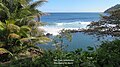 La Réunion Manapany tide pool.jpg 1,778 × 1,000; 730 KB
-
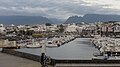 La Réunion Ville de Saint-Pierre - Port.jpg 1,778 × 1,000; 672 KB
-
 La Réunion vue des volcans.jpg 1,778 × 1,000; 467 KB
-
 Le Gros Morne (3019 m) - panoramio.jpg 3,264 × 2,448; 1.83 MB
-
 Les premiers rayons sur Marla - panoramio.jpg 3,264 × 2,448; 2.52 MB
-
 Marla depuis le sentier du Taibit - panoramio.jpg 3,264 × 2,448; 3.41 MB
-
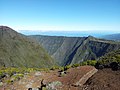
 Maïdo (Unsplash).jpg 6,000 × 4,000; 17.16 MB
-
 Maïdo Cirque de Mafate.jpg 1,024 × 679; 260 KB
-
 Montée du Taibit - panoramio.jpg 3,264 × 2,448; 3.62 MB
-
 Morne de l'étang - panoramio.jpg 3,264 × 2,448; 3.26 MB
-
 Nature La Réunion, janvier 2018 52.jpg 1,498 × 931; 263 KB
-
 Nature La Réunion, janvier 2018 53.jpg 1,395 × 930; 333 KB
-
 Nature La Réunion, janvier 2018 54.jpg 1,396 × 931; 141 KB
-
 Nature La Réunion, janvier 2018 55.jpg 1,396 × 931; 357 KB
-
 Nature La Réunion, janvier 2018 56.jpg 1,357 × 931; 231 KB
-
 Paysage des hauts - panoramio.jpg 3,264 × 2,448; 3.55 MB
-
 Piste de parapente de la rivière des remparts - panoramio.jpg 3,264 × 2,448; 1.65 MB
-
 Point de la Ravine Sèche - panoramio.jpg 3,264 × 2,448; 3.66 MB
-
 Puys Raymond vu depuis le sentier du Tremblet - panoramio.jpg 3,264 × 2,448; 3.52 MB
-
 Radier Terrain-Élisa.jpg 1,800 × 1,800; 1.53 MB
-
 Rempart des Sables au Volcan.jpg 7,291 × 4,863; 28.37 MB
-
 Rivière des marsouins - panoramio.jpg 3,264 × 2,448; 3.56 MB
-
 Roche Vert-bouteille - Paysage de La Réunion.jpg 6,012 × 3,382; 31.88 MB
-
 Roche Vert-Bouteille 2 - Paysage de l'île de La Réunion.jpg 4,674 × 3,106; 11.91 MB
-
 Saint benoit vue depuis le sentier dudu sup - panoramio.jpg 3,264 × 2,448; 2.64 MB
-
 Saint-Leu depuis Kelonia.jpg 3,264 × 2,448; 1.89 MB
-
 Salazie depuis Belouve.jpg 4,032 × 2,268; 6.88 MB
-
 Sentier du Nez coupé du Tremblet - panoramio.jpg 3,264 × 2,448; 3.44 MB
-
 Sentier Piton de Bert - panoramio.jpg 3,264 × 2,448; 3.29 MB
-
 Sunrise At Reunion Island 18th July 2017 (220207185).jpeg 1,200 × 800; 63 KB
-
 Takamaka - panoramio (1).jpg 3,264 × 2,448; 3.49 MB
-
 Takamaka dans la montée - panoramio.jpg 3,264 × 2,448; 3.31 MB
-
 Takamaka depuis le point de vue du morne de l'étang - panoramio.jpg 3,264 × 2,448; 3.48 MB
-
 Vallée de Takamaka - panoramio (1).jpg 3,264 × 2,448; 3.61 MB
-
 Volcan, Ile de la Réunion.jpg 4,320 × 3,240; 3.48 MB
-
 Vue depuis l'arrête du sentier dudu sup - panoramio.jpg 3,264 × 2,448; 3.34 MB
-
 Vue sur la côte depuis les citernes sainte-rose - panoramio.jpg 3,264 × 2,448; 3.49 MB
-
 Vue sur le cirque - panoramio.jpg 3,264 × 2,448; 3.37 MB
-
 Vue sur les montagne, sentier dudu - panoramio.jpg 3,264 × 2,448; 3.31 MB
-
 Végétation altimontaine des hauts de l'Île de la Réunion - panoramio.jpg 3,264 × 2,448; 3.32 MB
-
 Île de la Réunion.jpg 3,264 × 2,448; 1.71 MB
.jpeg)


_-_panoramio.jpg)


.jpg)


.jpeg)
.jpg)


.jpg)


