Category:Landschaftsschutzgebiet Nagoldtal
| Diese Kategorie repräsentiert ein Schutzgebiet nach Naturschutzrecht in Deutschland. |
|---|
| Diese Kategorie wurde nach einem klaren Schema angelegt, sie sollte nicht verschoben, gelöscht oder umkategorisiert werden. Sie ist unter anderem in dieser Uploadkarte hinterlegt. Beschreibung und Hintergründe auf der Seite des Wikiprojekts |
| Foto zu Wiki Loves Earth hochladen! - Seite von Wiki Loves Earth Deutschland |
This is the category of the protected area listed at WDPA under the ID 323115
|
Deutsch: Landschaftsschutzgebiet „Nagoldtal“, LSG 2.37.044 in Freudenstadt, Grömbach und Seewald, Landkreis Freudenstadt, Baden-Württemberg, Deutschland
English: Protected landscape area "Nagoldtal", ID 2.37.044 in Freudenstadt, Grömbach and Seewald, Landkreis Freudenstadt, Baden-Württemberg, Germany
protected landscape area in Baden-Württemberg, Germany | |||||
| Upload media | |||||
| Instance of | |||||
|---|---|---|---|---|---|
| Location | Freudenstadt, Karlsruhe Government Region, Baden-Württemberg, Germany | ||||
| IUCN protected areas category | |||||
| Inception |
| ||||
| Area |
| ||||
 | |||||
Subcategories
This category has the following 2 subcategories, out of 2 total.
L
- Lützenschlucht (25 F)
N
Media in category "Landschaftsschutzgebiet Nagoldtal"
The following 31 files are in this category, out of 31 total.
-
 20210404 16-45 alpha6k iso100 f6.3 400s Rotmilan Nagoldtalsperre.jpg 6,000 × 4,000; 3.22 MB
-
 A Fire Salamander that we found at the Xanderklinge waterfall in Baden-Wurttemburg.jpg 4,032 × 3,024; 2.88 MB
-

-

-

-

-

-

-

-

-

-

-

-

-

-

-

-

-

-

-

-

-

-

-

-

-
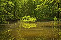 Weiher, Landschaftsschutzgebiet Nagoldtal, Kennung 2.35.037, 01.jpg 5,786 × 3,860; 7.21 MB
-
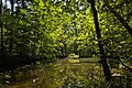
 Weiher, Landschaftsschutzgebiet Nagoldtal, Kennung 2.35.037, 02.jpg 5,786 × 3,860; 9.86 MB
-
 Weiher, Landschaftsschutzgebiet Nagoldtal, Kennung 2.35.037, 03.jpg 5,786 × 3,860; 8.32 MB
-
 Weiher, Landschaftsschutzgebiet Nagoldtal, Kennung 2.35.037, 04.jpg 5,786 × 3,860; 4.58 MB
-
 Weiher, Landschaftsschutzgebiet Nagoldtal, Kennung 2.35.037, 05.jpg 5,786 × 3,860; 5.53 MB


,_Kennung_2.35.037,_L%C3%BCtzengraben,_Wildberg_01.jpg)
,_Kennung_2.35.037,_L%C3%BCtzengraben,_Wildberg_03.jpg)
,_Kennung_2.35.037,_L%C3%BCtzengraben,_Wildberg_04.jpg)
,_Kennung_2.35.037,_L%C3%BCtzengraben,_Wildberg_05.jpg)
,_Kennung_2.35.037,_L%C3%BCtzengraben,_Wildberg_06.jpg)
,_Kennung_2.35.037,_L%C3%BCtzengraben,_Wildberg_07.jpg)
,_Kennung_2.35.037,_L%C3%BCtzengraben,_Wildberg_08.jpg)
,_Kennung_2.35.037,_L%C3%BCtzengraben,_Wildberg_10.jpg)
,_Kennung_2.35.037,_L%C3%BCtzengraben,_Wildberg_11.jpg)
,_Kennung_2.35.037,_L%C3%BCtzengraben,_Wildberg_12.jpg)
,_Kennung_2.35.037,_L%C3%BCtzengraben,_Wildberg_13.jpg)
,_Kennung_2.35.037,_L%C3%BCtzengraben,_Wildberg_14.jpg)
,_Kennung_2.35.037,_L%C3%BCtzengraben,_Wildberg_15.jpg)
,_Kennung_2.35.037,_L%C3%BCtzengraben,_Wildberg_16.jpg)
,_Kennung_2.35.037,_L%C3%BCtzengraben,_Wildberg_17.jpg)
,_Kennung_2.35.037,_L%C3%BCtzengraben,_Wildberg_18.jpg)
,_Kennung_2.35.037,_L%C3%BCtzengraben,_Wildberg_19.jpg)


