Category:Lange Steine Riedenberg
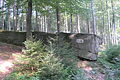
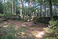
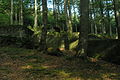
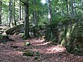
Lange Steine beim Röderhof/Riedenberg (Geotop im Landkreis Bad Kissingen), nördlich der Sinn am Rand des Truppenübungsplatzes Wildflecken
Geotop in Landkreis Bad Kissingen in Bavaria, Germany  | |||||
| Upload media | |||||
| Instance of | |||||
|---|---|---|---|---|---|
| Location | Römershager Forst-Nord, Bad Kissingen, Lower Franconia, Bavaria, Germany | ||||
| Width |
| ||||
| Length |
| ||||
| Area |
| ||||
| Elevation above sea level |
| ||||
| official website | |||||
 | |||||
Media in category "Lange Steine Riedenberg"
The following 18 files are in this category, out of 18 total.
-
 KG GEOT Lange Steine 2006Jul 00.JPG 2,592 × 1,728; 756 KB
-
 KG GEOT Lange Steine 2006Jul 01.JPG 2,592 × 1,728; 995 KB
-
 KG GEOT Lange Steine 2006Jul 02.JPG 2,592 × 1,728; 755 KB
-
 KG GEOT Lange Steine 2006Jul 03.JPG 2,592 × 1,728; 795 KB
-
 KG GEOT Lange Steine 2006Jul 04.JPG 2,592 × 1,728; 740 KB
-
 KG GEOT Lange Steine 2006Jul 05.jpg 1,728 × 2,592; 1.08 MB
-
 KG GEOT Lange Steine 2006Jul 06.JPG 2,592 × 1,728; 764 KB
-
 Riedenberg Sept 2015 Lange Steine 01.JPG 4,000 × 3,000; 5.49 MB
-
 Riedenberg Sept 2015 Lange Steine 02.JPG 4,000 × 3,000; 5.45 MB
-
 Riedenberg Sept 2015 Lange Steine 03.JPG 4,000 × 3,000; 5.75 MB
-
 Riedenberg Sept 2015 Lange Steine 04.JPG 4,000 × 3,000; 5.63 MB
-
 Riedenberg Sept 2015 Lange Steine 05.JPG 4,000 × 3,000; 6.04 MB
-
 Riedenberg Sept 2015 Lange Steine 06.JPG 4,000 × 3,000; 5.6 MB
-
 Riedenberg Sept 2015 Lange Steine 07.JPG 4,000 × 3,000; 5.23 MB
-
 Riedenberg Sept 2015 Lange Steine 08.JPG 3,000 × 4,000; 6.09 MB
-
 Riedenberg Sept 2015 Lange Steine 09.JPG 4,000 × 3,000; 6.36 MB
-
 Riedenberg Sept 2015 Lange Steine 10.JPG 4,000 × 3,000; 6.01 MB
-
 Riedenberg Sept 2015 Lange Steine 11.JPG 4,000 × 3,000; 5.27 MB


