Category:Langstone, Hampshire
village in Hampshire, England, UK  | |||||
| Upload media | |||||
| Instance of | |||||
|---|---|---|---|---|---|
| Location | Havant, Hampshire, South East England, England | ||||
| Different from | |||||
 | |||||
English: Langstone is a village near Havant, Hampshire in the south east of England, between Portsmouth and Chichester. It has good railway connections to London, Southampton, Portsmouth and Brighton, from the nearby Havant railway station. There are many large gated detached houses on the main road, "Langstone Road" and on the roads surrounding this. It has a sailing club, several architecturally unusual buildings, and several historically significant buildings, including a converted (water) millhouse and a converted 18th century windmill, the latter of which is a local landmark.
Subcategories
This category has the following 9 subcategories, out of 9 total.
L
- Langston railway station (2 F)
- Langstone Bridge (14 F)
- Langstone Mill (28 F)
R
- Royal Oak, Langstone (22 F)
S
- The Ship Inn, Langstone (14 F)
W
Media in category "Langstone, Hampshire"
The following 164 files are in this category, out of 164 total.
-
 "I ain't seen snow like this since 1947" - geograph.org.uk - 754066.jpg 640 × 480; 143 KB
-
 16-18 Langstone High Street, The Royal Oak pub - 53536845048.jpg 4,000 × 2,250; 9.17 MB
-
 27 bus at Green Pond Corner - geograph.org.uk - 682493.jpg 640 × 480; 64 KB
-
 3–7 Langstone High Street, Langstone (May 2019).JPG 2,000 × 1,500; 1.22 MB
-

-
 A less famous B.B.C. - geograph.org.uk - 640749.jpg 640 × 480; 71 KB
-
 A New Year’s Eve Eve Walk (64) - geograph.org.uk - 2773344.jpg 640 × 480; 59 KB
-
 A pleasant spot for my lunch - geograph.org.uk - 687896.jpg 640 × 480; 66 KB
-
 Aker Solutions in the snow - geograph.org.uk - 754029.jpg 640 × 480; 49 KB
-
 And you are^ - geograph.org.uk - 1320966.jpg 640 × 480; 112 KB
-
 Beautiful river at Langstone - geograph.org.uk - 687939.jpg 640 × 480; 35 KB
-
 Boats anchored at Langstone Harbour.jpg 4,000 × 3,000; 6.11 MB
-
 Brockhampton - geograph.org.uk - 5119.jpg 640 × 427; 179 KB
-
 Canine company on the Wayfarers - geograph.org.uk - 690846.jpg 640 × 480; 85 KB
-
 Cottages in Langstone High Street, Hampshire - geograph.org.uk - 1724529.jpg 2,592 × 3,872; 2.58 MB
-
 Cycle Route at Langstone, Hampshire - geograph.org.uk - 1724545.jpg 3,872 × 2,592; 5.84 MB
-
 Cycle Route, Langstone, Hampshire - geograph.org.uk - 1721169.jpg 3,872 × 2,592; 5.56 MB
-

-
 Entrance to Langstone High Street - geograph.org.uk - 2863959.jpg 640 × 434; 74 KB
-

-

-
 Flood defence door.jpg 1,024 × 768; 172 KB
-
 Footpath junction at South Moor - geograph.org.uk - 1215769.jpg 640 × 480; 97 KB
-
 Footpath junction within South Moor - geograph.org.uk - 1217881.jpg 640 × 480; 128 KB
-
 Harbour Night Langstone (2810851306).jpg 2,048 × 1,355; 71 KB
-
 Harbour Night Langstone (2810851468).jpg 2,048 × 1,356; 121 KB
-
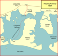 Hayling 1864.png 1,050 × 1,010; 80 KB
-
 Hayling Billy Trail - geograph.org.uk - 2932371.jpg 2,048 × 1,536; 691 KB
-

-
 Hilton Hotel, Newport - geograph.org.uk - 148323.jpg 640 × 426; 124 KB
-

-
 Langstone - geograph.org.uk - 176536.jpg 640 × 440; 152 KB
-
 Langstone - panoramio.jpg 2,592 × 1,936; 1.87 MB
-
 Langstone Harbour.jpg 4,000 × 3,000; 5.88 MB
-
 Langstone High Street - panoramio.jpg 1,024 × 768; 276 KB
-
 Langstone High Street, Hampshire - geograph.org.uk - 1724523.jpg 3,872 × 2,592; 2.12 MB
-
 Langstone map 1945.jpg 492 × 330; 138 KB
-
 Langstone Quay - geograph.org.uk - 1510452.jpg 640 × 360; 42 KB
-
 Langstone Sailing Club - geograph.org.uk - 1510434.jpg 640 × 360; 63 KB
-
 Langstone Sailing Club, Hampshire - geograph.org.uk - 1720045.jpg 3,872 × 2,592; 4.64 MB
-
 Langstone Sailing Club, Hampshire - geograph.org.uk - 1720055.jpg 3,872 × 2,592; 3.49 MB
-
 Looking Across Langstone Harbour, Hampshire - geograph.org.uk - 1724619.jpg 3,872 × 2,592; 4.54 MB
-

-

-
 Looking down Town Hall Road - geograph.org.uk - 635799.jpg 640 × 480; 78 KB
-

-
-

-

-

-

-
 Looking northwards up Grove Road - geograph.org.uk - 803136.jpg 640 × 480; 65 KB
-

-

-
-
 Looking southwards down Wade Lane - geograph.org.uk - 1321145.jpg 640 × 480; 110 KB
-
 Looking towards Emsworth on the A27 - geograph.org.uk - 676979.jpg 640 × 480; 47 KB
-

-
 Lovely old wall at end of Mill Lane - geograph.org.uk - 688160.jpg 480 × 640; 73 KB
-

-

-

-
 National Cycle Route 2 - geograph.org.uk - 1575198.jpg 640 × 480; 108 KB
-
 New jobs coming to Havant - geograph.org.uk - 1474259.jpg 640 × 480; 57 KB
-
 No better day for a walk - geograph.org.uk - 690930.jpg 640 × 480; 62 KB
-
 Norris Gardens - geograph.org.uk - 681707.jpg 640 × 480; 93 KB
-

-
 Old Railway - geograph.org.uk - 371154.jpg 640 × 480; 60 KB
-
 Panorama of Langstone Village.jpg 4,980 × 2,808; 6.6 MB
-
 Parc in South Street - geograph.org.uk - 790714.jpg 480 × 640; 67 KB
-

-
 Path to the pub, Langstone, Hampshire - geograph.org.uk - 1721446.jpg 2,592 × 3,872; 2.7 MB
-

-
 Phone box on main road at Langstone - geograph.org.uk - 689640.jpg 640 × 480; 128 KB
-

-
 Pillbox by Langstone Harbour - geograph.org.uk - 1507435.jpg 640 × 474; 100 KB
-
 Power lines in Pook Lane - geograph.org.uk - 677579.jpg 640 × 480; 65 KB
-
 Rabbits in the field just off Wade Lane - geograph.org.uk - 1321160.jpg 640 × 480; 128 KB
-

-
 Rectory Cottage - geograph.org.uk - 677538.jpg 640 × 480; 66 KB
-
 Rectory Stables - geograph.org.uk - 677543.jpg 640 × 480; 73 KB
-

-
 Scaffolding on flats in East Street - geograph.org.uk - 1337994.jpg 480 × 640; 80 KB
-
 Seat dedicated to a walker - geograph.org.uk - 690860.jpg 640 × 480; 119 KB
-
 Seat in Church Lane - geograph.org.uk - 681703.jpg 640 × 480; 111 KB
-

-
 Semi-detached houses in Springwell - geograph.org.uk - 1210849.jpg 480 × 640; 72 KB
-
 Signal on Hayling Branch Line - geograph.org.uk - 1508512.jpg 402 × 640; 45 KB
-
 Small green just off Grove Road - geograph.org.uk - 803121.jpg 640 × 480; 109 KB
-

-
 Solent Way - geograph.org.uk - 1575149.jpg 640 × 480; 70 KB
-
 South Close - geograph.org.uk - 676419.jpg 640 × 480; 76 KB
-
 South Moor - geograph.org.uk - 1217875.jpg 640 × 480; 84 KB
-
 Splendid house in Wade Court Road - geograph.org.uk - 676394.jpg 640 × 480; 67 KB
-
 Spring at Wade Court Farm - geograph.org.uk - 1321169.jpg 640 × 447; 63 KB
-

-

-

-
 Superb house at the end of Mill Lane - geograph.org.uk - 688175.jpg 640 × 480; 110 KB
-
 Swans feeding at Langstone - geograph.org.uk - 690830.jpg 640 × 480; 95 KB
-
 Take up thy bike and walk - geograph.org.uk - 690910.jpg 480 × 640; 120 KB
-
 The Green Cottage, Langstone Village.jpg 4,000 × 3,000; 5.25 MB
-

-
 The Tide's in at Langstone. - geograph.org.uk - 176540.jpg 640 × 439; 99 KB
-
 There for a purpose - geograph.org.uk - 981807.jpg 480 × 640; 105 KB
-
 Tide in at Langstone - geograph.org.uk - 1324733.jpg 480 × 640; 83 KB
-

-
 Tricky section along the Wayfarers - geograph.org.uk - 690901.jpg 640 × 480; 126 KB
-
 Unromantic necessity - geograph.org.uk - 676987.jpg 640 × 480; 132 KB
-
 View Across Chichester Harbour - geograph.org.uk - 1717793.jpg 3,872 × 2,592; 3.46 MB
-
 View Across Chichester Harbour - geograph.org.uk - 1717805.jpg 3,872 × 2,592; 3.99 MB
-
 View Across Chichester Harbour - geograph.org.uk - 1720247.jpg 2,032 × 1,360; 1.32 MB
-
 View Across Chichester Harbour - geograph.org.uk - 1721042.jpg 3,872 × 2,176; 2.29 MB
-
 View Across Langstone Harbour, Hampshire - geograph.org.uk - 1720079.jpg 3,864 × 1,687; 1.11 MB
-

-

-
 View looking towards Wade Court Road - geograph.org.uk - 690888.jpg 640 × 480; 116 KB
-
 Wade Court and Wade Court Farm.jpg 1,898 × 1,266; 2.52 MB
-
 Walking the dog in Wade Lane - geograph.org.uk - 1321153.jpg 640 × 480; 114 KB
-
 We Three, Chichester Harbour - geograph.org.uk - 1721381.jpg 3,872 × 2,592; 1.94 MB
-
 Winter trees in Pook Lane - geograph.org.uk - 677562.jpg 640 × 480; 131 KB
-
 Winter trees in Wade Court Road - geograph.org.uk - 1672195.jpg 640 × 480; 93 KB
-
 A gentle stroll at North Hayling - geograph.org.uk - 1421221.jpg 640 × 480; 79 KB
-

-

-
 A3023 Langstone - geograph.org.uk - 1435045.jpg 640 × 480; 123 KB
-

-
 Bed and Breakfast in Havant Road - geograph.org.uk - 1421222.jpg 640 × 480; 101 KB
-
 Boat goes along Northney Road - geograph.org.uk - 1506630.jpg 640 × 360; 48 KB
-
 Boats crossing - geograph.org.uk - 1506528.jpg 640 × 360; 35 KB
-
 Boats crossing sign - geograph.org.uk - 1510442.jpg 640 × 360; 47 KB
-
 Bridge to Mill Lane - geograph.org.uk - 688077.jpg 640 × 480; 122 KB
-

-
 Brockhampton Lane Industry - geograph.org.uk - 363496.jpg 640 × 480; 59 KB
-
 Elusive pipeline - geograph.org.uk - 687842.jpg 480 × 640; 86 KB
-
 Erosion of old road - geograph.org.uk - 111380.jpg 640 × 480; 78 KB
-
 Fishermen's cottages at Langstone - geograph.org.uk - 689652.jpg 640 × 480; 60 KB
-

-

-
 Frosty Field - geograph.org.uk - 111375.jpg 640 × 480; 48 KB
-
 Harbourside, Langstone - geograph.org.uk - 688208.jpg 640 × 480; 106 KB
-
 Hayling Island from Langstone Mill - geograph.org.uk - 1233.jpg 640 × 480; 71 KB
-
 Hayling Oysterbeds - geograph.org.uk - 371197.jpg 640 × 480; 63 KB
-
 Hayling Oysterbeds - geograph.org.uk - 371200.jpg 640 × 480; 90 KB
-
 Junction of Mill Lane and Harbourside - geograph.org.uk - 688228.jpg 640 × 480; 128 KB
-
 Langstone Bridge from Northney road - geograph.org.uk - 559595.jpg 640 × 480; 67 KB
-
 Langstone Harbour - geograph.org.uk - 363491.jpg 640 × 480; 88 KB
-
 Looking East from Langstone Bridge - geograph.org.uk - 321614.jpg 640 × 480; 91 KB
-

-
 Looking towards Mill Lane - geograph.org.uk - 687816.jpg 640 × 480; 55 KB
-
-
 Mill Lane, Langstone - geograph.org.uk - 688190.jpg 640 × 480; 141 KB
-
 Modern housing at Langstone - geograph.org.uk - 689646.jpg 640 × 480; 60 KB
-
 Mudflats - geograph.org.uk - 371187.jpg 640 × 480; 53 KB
-
 Pretty bridge near Mill Lane - geograph.org.uk - 688062.jpg 640 × 480; 59 KB
-
 Rear of houses in Mill Lane - geograph.org.uk - 687929.jpg 640 × 480; 49 KB
-
 Southbrook Road, Havant - geograph.org.uk - 41515.jpg 640 × 404; 124 KB
-
 Stream and footpath, Havant - geograph.org.uk - 148513.jpg 640 × 480; 126 KB
-
 Stream and the A27, Havant - geograph.org.uk - 148511.jpg 480 × 640; 148 KB
-
 This really was taken in February^ - geograph.org.uk - 687801.jpg 640 × 480; 46 KB
-
 Unlovely gate near Mill Lane - geograph.org.uk - 688010.jpg 640 × 480; 63 KB
-
 Verdant scene for early February - geograph.org.uk - 688237.jpg 640 × 480; 142 KB
-
 Wayfarers Walk path at Langstone - geograph.org.uk - 688267.jpg 640 × 480; 171 KB
-
 Wentworth Hills - geograph.org.uk - 120776.jpg 640 × 481; 30 KB


.JPG)


_-_geograph.org.uk_-_2773344.jpg)


.jpg)
.jpg)


