Category:Laurencekirk
town in Aberdeenshire, Scotland, UK  | |||||
| Upload media | |||||
| Instance of |
| ||||
|---|---|---|---|---|---|
| Location |
| ||||
| Population |
| ||||
 | |||||
English: Laurencekirk is a small town in the ancient county of Kincardineshire, modern county of Aberdeenshire, Scotland, just off the A90 Dundee to Aberdeen main road. It is the largest settlement in the Howe o' the Mearns area and houses the local secondary school; Mearns Academy, which was awarded the Charter Mark in 2003. The 2004 population is estimated at 3,596.
Simple English: Laurencekirk is a small town in the ancient county of Kincardineshire, modern county of Aberdeenshire, Scotland, just off the A90 Dundee to Aberdeen main road. It is the largest settlement in the Howe o' the Mearns area and houses the local secondary school; Mearns Academy, which was awarded the Charter Mark in 2003. The 2004 population is estimated at 3,596.
Subcategories
This category has the following 2 subcategories, out of 2 total.
L
- Laurencekirk railway station (5 F)
Media in category "Laurencekirk"
The following 81 files are in this category, out of 81 total.
-
 A River Valley - geograph.org.uk - 90287.jpg 640 × 475; 59 KB
-
 A90 from Laurencekirk Junction - geograph.org.uk - 90239.jpg 640 × 475; 56 KB
-
 A90 over Bervie Water - geograph.org.uk - 168584.jpg 640 × 475; 127 KB
-
 Cloch-na Hill near Temple of Fiddes - geograph.org.uk - 141568.jpg 640 × 475; 50 KB
-
 Cottage Doorway - geograph.org.uk - 1705904.jpg 480 × 640; 298 KB
-
 Craig of Garvock - geograph.org.uk - 197897.jpg 640 × 401; 98 KB
-
 Criggie Farm and Fields - geograph.org.uk - 99589.jpg 640 × 475; 56 KB
-
 Depot in disused quarry at Whinhill - geograph.org.uk - 1383776.jpg 640 × 331; 40 KB
-
 Detail of Doorway - geograph.org.uk - 1705912.jpg 640 × 478; 235 KB
-
 Dickson Hall, Laurencekirk - geograph.org.uk - 1010109.jpg 640 × 426; 66 KB
-
 East Coast Main Line near Scotston - geograph.org.uk - 153567.jpg 640 × 475; 102 KB
-
 Farmland at old road - Blackiemuir - geograph.org.uk - 35610.jpg 640 × 480; 97 KB
-
 Former drill hall, High Street, Laurencekirk (geograph 6144216).jpg 4,763 × 3,575; 4.24 MB
-

-

-
 Laurencekirk - geograph.org.uk - 1779578.jpg 640 × 480; 70 KB
-
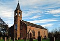 Laurencekirk Church 2.JPG 3,652 × 2,476; 2.1 MB
-
 Laurencekirk churchyard. - geograph.org.uk - 1141166.jpg 427 × 640; 69 KB
-
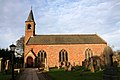
 Laurencekirk Episcopalian Church.JPG 2,442 × 3,613; 2.08 MB
-
 Laurencekirk kirk - geograph.org.uk - 1141148.jpg 427 × 640; 59 KB
-
 Laurencekirk Library - geograph.org.uk - 1009491.jpg 640 × 427; 73 KB
-
 Laurencekirk Parish Church - geograph.org.uk - 1141157.jpg 640 × 427; 57 KB
-
 Laurencekirk Station Platform - geograph.org.uk - 1332257.jpg 640 × 480; 137 KB
-
 Laurencekirk.jpg 640 × 427; 153 KB
-
 Lochans and Brandshill Woods - geograph.org.uk - 90283.jpg 640 × 475; 54 KB
-
 Masonic Hall, Laurencekirk - geograph.org.uk - 1009475.jpg 640 × 427; 48 KB
-
 Mini supermarket, Laurencekirk... (geograph 6143304).jpg 5,042 × 3,474; 4.56 MB
-

-
 Ruin of Garvock Church - geograph.org.uk - 187629.jpg 640 × 480; 91 KB
-
 St Palladius Church - panoramio.jpg 4,272 × 2,848; 12.5 MB
-
 St. Laurence Hall, Laurencekirk - geograph.org.uk - 1009469.jpg 640 × 427; 59 KB
-

-

-

-

-
 View in Garvock Road, Laurencekirk - geograph.org.uk - 1010103.jpg 640 × 426; 127 KB
-
 View in Garvock Street, Laurencekirk - geograph.org.uk - 1010094.jpg 640 × 426; 127 KB
-
 View of High Street, Laurencekirk - geograph.org.uk - 1009472.jpg 640 × 426; 68 KB
-
 War Memorial, Laurencekirk - geograph.org.uk - 935118.jpg 480 × 640; 72 KB
-
 Waterside of Newton - geograph.org.uk - 33554.jpg 640 × 480; 131 KB
-
 West Bradieston Farm - geograph.org.uk - 90272.jpg 640 × 475; 61 KB
-
 Western Inn Laurencekirk.jpg 3,104 × 2,372; 1.71 MB
-

-

-
 Blackiemuir Farm - geograph.org.uk - 88733.jpg 640 × 421; 120 KB
-

-
 Burn of Balmakelly - geograph.org.uk - 90291.jpg 640 × 475; 79 KB
-
 Burnton Farm on Hill of Garvock - geograph.org.uk - 90241.jpg 640 × 475; 52 KB
-
 Cairn on Garvock Hill - geograph.org.uk - 339940.jpg 640 × 426; 97 KB
-
 Chalybeate Well - geograph.org.uk - 345275.jpg 640 × 480; 142 KB
-
 Farm Machinery - geograph.org.uk - 109120.jpg 640 × 475; 75 KB
-
 Farm road - geograph.org.uk - 35607.jpg 640 × 480; 50 KB
-

-
 Free Range Chicken Coups - geograph.org.uk - 123281.jpg 640 × 426; 64 KB
-

-
 Horse in a Field by Denlethen Woods - geograph.org.uk - 90232.jpg 640 × 475; 60 KB
-

-

-
 Kilnhill by Laurencekirk - geograph.org.uk - 197884.jpg 640 × 427; 133 KB
-
 Kinnear Square - Laurencekirk - geograph.org.uk - 92056.jpg 640 × 427; 237 KB
-
 Laurencekirk from the Garvock Hill - geograph.org.uk - 116227.jpg 640 × 480; 66 KB
-
 Laurencekirk High Street - geograph.org.uk - 90238.jpg 640 × 475; 64 KB
-
 Laurencekirk in the distance - geograph.org.uk - 94450.jpg 640 × 421; 70 KB
-

-
 Looking up Hill of Garvock - geograph.org.uk - 90275.jpg 640 × 475; 64 KB
-
 Looking up the Hill of Garvock - geograph.org.uk - 99461.jpg 640 × 475; 68 KB
-
 Lower Scotston Farm - geograph.org.uk - 123296.jpg 640 × 475; 80 KB
-
 Mains of Haulkerton - geograph.org.uk - 123284.jpg 640 × 475; 88 KB
-
 Mains of Newton Farmhouse - geograph.org.uk - 99465.jpg 640 × 475; 74 KB
-
 NO7266 - geograph.org.uk - 99496.jpg 640 × 475; 58 KB
-
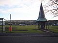 Playpark in Laurencekirk - geograph.org.uk - 90237.jpg 640 × 475; 76 KB
-
 Road to Mill of Haulkerton - geograph.org.uk - 123285.jpg 640 × 475; 104 KB
-
 Road to Upperton - geograph.org.uk - 155995.jpg 475 × 640; 109 KB
-
 Road with Passing Places - geograph.org.uk - 90285.jpg 640 × 475; 61 KB
-
 Scotston Junction A90 - geograph.org.uk - 153574.jpg 640 × 475; 85 KB
-
 South Barns Farm - geograph.org.uk - 90295.jpg 640 × 475; 60 KB
-

-
 The Tower of Johnston - geograph.org.uk - 67124.jpg 640 × 480; 73 KB
-
 Trig Point and Beehives near A90 - geograph.org.uk - 123295.jpg 640 × 475; 121 KB
-
 View to North West from Denlethen Wood - geograph.org.uk - 91432.jpg 640 × 418; 108 KB
-
 Waterside Cottage from the Farm - geograph.org.uk - 35589.jpg 640 × 480; 62 KB


.jpg)


.jpg)


