Category:Laurentiuskerk, Mijnsheerenland
| Object location | | View all coordinates using: OpenStreetMap |
|---|
church building in Binnenmaas, Netherlands  | |||||
| Upload media | |||||
| Instance of | |||||
|---|---|---|---|---|---|
| Location | Mijnsheerenland, Hoeksche Waard, South Holland, Netherlands | ||||
| Street address |
| ||||
| Has part(s) | |||||
| Inception |
| ||||
 | |||||
Kerk:
|
This is a category about rijksmonument number 30147
|
Toren:
|
This is a category about rijksmonument number 30148
|
| Address |
|
Subcategories
This category has only the following subcategory.
G
Media in category "Laurentiuskerk, Mijnsheerenland"
The following 47 files are in this category, out of 47 total.
-
 Boog - Mijnsheerenland - 20159255 - RCE.jpg 1,200 × 1,194; 311 KB
-

-

-
 Exterieur noord-west zijde - Mijnsheerenland - 20159232 - RCE.jpg 953 × 1,200; 365 KB
-
 Exterieur overzicht naar het noord-westen - Mijnsheerenland - 20159230 - RCE.jpg 948 × 1,200; 271 KB
-
 Exterieur overzicht naar het zuid-oosten - Mijnsheerenland - 20159229 - RCE.jpg 963 × 1,200; 260 KB
-
 Exterieur overzicht naar het zuid-westen - Mijnsheerenland - 20159228 - RCE.jpg 958 × 1,200; 250 KB
-

-

-

-
 Halve boog - Mijnsheerenland - 20159256 - RCE.jpg 1,200 × 1,198; 314 KB
-
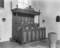 Herenbank - Mijnsheerenland - 20159260 - RCE.jpg 1,200 × 962; 166 KB
-
 Herenbank - Mijnsheerenland - 20159261 - RCE.jpg 1,200 × 954; 200 KB
-
 Ingangsportaal zuid-zijde - Mijnsheerenland - 20159267 - RCE.jpg 948 × 1,200; 322 KB
-
 Interieur naar het oosten - Mijnsheerenland - 20159240 - RCE.jpg 1,200 × 943; 212 KB
-
 Interieur naar het oosten - Mijnsheerenland - 20159257 - RCE.jpg 958 × 1,200; 183 KB
-
 Interieur naar het oosten - Mijnsheerenland - 20159265 - RCE.jpg 950 × 1,200; 167 KB
-
 Interieur naar het westen - Mijnsheerenland - 20159239 - RCE.jpg 960 × 1,200; 229 KB
-
 Interieur naar het westen - Mijnsheerenland - 20159258 - RCE.jpg 956 × 1,200; 180 KB
-
 Interieur naar het westen - Mijnsheerenland - 20159263 - RCE.jpg 958 × 1,200; 213 KB
-

-
 Interieur, overzicht van muurschildering - Mijnsheerenland - 20383236 - RCE.jpg 1,200 × 1,177; 251 KB
-
 Kap van het schip - Mijnsheerenland - 20159245 - RCE.jpg 1,200 × 1,200; 224 KB
-
 Kap van het schip - Mijnsheerenland - 20159246 - RCE.jpg 1,200 × 1,200; 211 KB
-
 Kap van het schip - Mijnsheerenland - 20159247 - RCE.jpg 1,200 × 1,200; 235 KB
-
 Kap van het schip - Mijnsheerenland - 20159248 - RCE.jpg 1,200 × 1,167; 264 KB
-
 Koor interieur naar het oosten - Mijnsheerenland - 20159264 - RCE.jpg 951 × 1,200; 154 KB
-
 Koorpartij zuid-oost zijde - Mijnsheerenland - 20159236 - RCE.jpg 959 × 1,200; 384 KB
-
 Koorpartij zuid-zijde - Mijnsheerenland - 20159237 - RCE.jpg 962 × 1,200; 334 KB
-
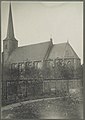
 Mijnsheerenland kerk.jpg 1,944 × 2,592; 2.17 MB
-
 Muurschildering noord-gevel oost-zijde - Mijnsheerenland - 20159259 - RCE.jpg 946 × 1,200; 150 KB
-
 Nederlands Hervormde Kerk en toren - Mijnsheerenland - 20159234 - RCE.jpg 1,200 × 949; 278 KB
-
 Orgel - Mijnsheerenland - 20159262 - RCE.jpg 954 × 1,200; 187 KB
-
 Overzicht - Mijnsheerenland - 20159316 - RCE.jpg 1,200 × 1,200; 269 KB
-
 Overzicht dorp - Mijnsheerenland - 20159223 - RCE.jpg 1,200 × 804; 262 KB
-
 Overzicht naar de kerk - Mijnsheerenland - 20159337 - RCE.jpg 1,200 × 1,197; 305 KB
-
 Overzicht naar de kerk - Mijnsheerenland - 20159338 - RCE.jpg 1,186 × 1,200; 266 KB
-
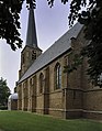
 Overzicht vanuit het zuidoosten - Mijnsheerenland - 20325637 - RCE.jpg 850 × 1,200; 175 KB
-
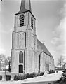
 Overzicht zuidgevel - Mijnsheerenland - 20377409 - RCE.jpg 2,788 × 3,574; 3.93 MB
-
 Toegangshek zuid-zijde - Mijnsheerenland - 20159270 - RCE.jpg 943 × 1,200; 266 KB
-
 Torenvoet west-zijde - Mijnsheerenland - 20159226 - RCE.jpg 946 × 1,200; 321 KB
-
 Torenvoet zuid-zijde - Mijnsheerenland - 20159227 - RCE.jpg 950 × 1,200; 399 KB
-
 Voorgevel - Mijnsheerenland - 20159318 - RCE.jpg 1,192 × 1,200; 338 KB
-
 Zuid-gevel west-zijde - Mijnsheerenland - 20159266 - RCE.jpg 944 × 1,200; 255 KB
-
 Zuid-oost zijde exterieur - Mijnsheerenland - 20159268 - RCE.jpg 1,200 × 947; 263 KB
-
 Zuid-oost zijde exterieur - Mijnsheerenland - 20159269 - RCE.jpg 944 × 1,200; 229 KB
-
 Zuid-west zijde met toren - Mijnsheerenland - 20159271 - RCE.jpg 938 × 1,200; 238 KB


