<nowiki>Laveraët; Laveraët; Laveraët; Laveraët; Laveraët; Laveraët; Laveraët; 拉韋拉厄; Laveraët; Laveraët; Лаверае; 拉韋拉厄; Laveraët; Laveraët; Laveraët; Laveraët; Laveraët; Laveraët; Laveraët; Laveraët; Laveraët; Laveraët; Laveraët; Laveraët; Laveraët; Laveraët; Laveraët; Laveraët; Laveraët; Laveraët; Laveraët; Laveraët; Laveraët; 拉韦拉厄; Laveraët; Laveraët; Laveraët; L'Agroet; Laveraët; Laveraët; Laveraët; Лавераэт; L'Agroet; Laveraët; Laveraët; Laveraët; Laveraët; Laveraët; Laveraët; ЛавегӀаэт; Laveraët; Laveraët; 拉韦拉厄; Laveraët; Laveraët; ラヴラエ; Laveraët; Laveraët; Laveraët; Laveraët; Laveraët; Laveraët; Laveraët; Laveraët; Laveraët; Laveraët; Laveraët; Laveraët; Laveraët; Laveraët; Laveraët; Laveraët; Laveraët; Laveraët; Laveraët; Laveraët; Laveraët; Laveraët; Laveraët; Laveraët; Laveraët; Laveraët; Laveraët; L'Agroet; Laveraët; Laveraët; Laveraët; Laveraët; Laveraët; Laveraët; Laveraët; Laveraët; Laveraët; Laveraët; Laveraët; Laveraët; Laveraët; Laveraët; Laveraët; Laveraët; Laveraët; Лавераэт; comune francese; commune française du département du Gers; municipi francès; sveitarfélag í Frakklandi; 法国市镇; بلدية في فرنسا; chemun de la Franzia; коммуна во Франции; kumun Bro-C'hall; französische Gemeinde; comuna francesa; komunë në departamentin Gers, Francë; comuna francesa; 法国市镇; komuna departmena Gersê, Oksîtanya, Fransa; Fransa'da komün; フランスのコミューン; Gemeen in dat Département Gers, Frankriek; una comuna francesa; fransk kommun i departementet Gers; gemeente in Gers, Frankrijk; муніципалітет у департаменті Жер, Франція; komune di Peurancih; 法國市鎮; obec v departementu Gers ve Francii; obec v departemente Gers vo Francúzsku; település Franciaországban; commune in Gers, France; komunumo en la departemento Gers de Francio; comun fransexo; kommune i Gers i Frankrike; Laveraët; Jean-Claude Lascombes; Laveraet; Laveraët; Laveraet</nowiki>


 32205-Laveraët-Routes-Hydro.png 3,507 × 2,480; 1.43 MB
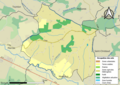 32205-Laveraët-Sols.png 3,507 × 2,480; 1.58 MB
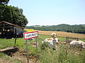 Laveraët (Gers, Fr) paysage.JPG 4,000 × 3,000; 4.17 MB
 Laveraët 01.jpg 3,672 × 4,896; 7.19 MB
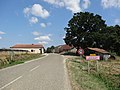 Laveraët 02.jpg 4,742 × 3,556; 3.8 MB
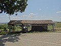 Laveraët 03.jpg 4,896 × 3,672; 6.13 MB
 Laveraët 04.jpg 4,896 × 3,672; 8.66 MB
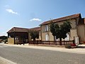 Laveraët 05.jpg 4,896 × 3,672; 5.6 MB
 Laveraët 06.jpg 4,896 × 3,672; 6 MB
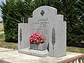 Laveraët 12.jpg 4,847 × 3,634; 5.76 MB
 Map commune FR insee code 32205.png 756 × 605; 35 KB
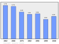 Population - Municipality code 32205.svg 475 × 355; 13 KB

_paysage.JPG)


