Category:Lesko town hall
| Object location | | View all coordinates using: OpenStreetMap |
|---|
 | |||||
| Upload media | |||||
| Instance of | |||||
|---|---|---|---|---|---|
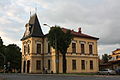
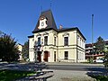
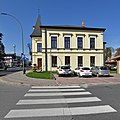
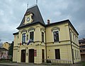
| Location | Lesko, Gmina Lesko, Lesko County, Subcarpathian Voivodeship, Poland | ||||
| Heritage designation |
| ||||
 | |||||
Media in category "Lesko town hall"
The following 16 files are in this category, out of 16 total.
-
 Lesko - Town hall 01.jpg 3,994 × 2,664; 3.12 MB
-
 Lesko, ratusz (HB1).jpg 2,702 × 2,027; 2.37 MB
-
 Lesko, ratusz (HB2).jpg 2,789 × 2,790; 5.46 MB
-
 Lesko, ratusz (HB3).jpg 3,774 × 2,516; 4.88 MB
-
 Lesko, ratusz (HB4).jpg 3,403 × 2,521; 4.23 MB
-
 Lesko, ratusz (HB5).jpg 2,673 × 2,673; 3.36 MB
-
 Lesko, ratusz (HB6).jpg 2,317 × 1,738; 2.91 MB
-
 Lesko, ratusz (HB7).jpg 3,058 × 2,039; 4.18 MB
-
 Lesko, Ratusz.jpg 1,672 × 2,420; 1.22 MB
-
 Lesko. Ratusz 1.jpg 1,181 × 879; 260 KB
-
 Lesko. Ratusz 2.jpg 1,186 × 896; 280 KB
-
 Lesko. Ratusz 3.jpg 1,159 × 884; 261 KB
-
 Plaque to 500 years of city 1470-1970 on town hall in Lesko (2017).jpg 2,457 × 3,189; 2.12 MB
-
 Town hall in Lesko (2017)a.jpg 3,628 × 2,592; 2.73 MB
-
 Town hall in Lesko (2017)b.jpg 3,308 × 2,592; 2.51 MB
-
 Town hall in Lesko (2017)c.jpg 2,592 × 3,872; 2.46 MB
.jpg)
.jpg)
.jpg)
.jpg)
.jpg)
.jpg)
.jpg)


.jpg)
a.jpg)
b.jpg)
c.jpg)