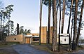
Category:Lilla Aska kapellkrematorium
| Object location | | View all coordinates using: OpenStreetMap |
|---|
 | |||||
| Upload media | |||||
| Instance of | |||||
|---|---|---|---|---|---|
| Location | |||||
| Architect | |||||
| Has use | |||||
| Heritage designation |
| ||||
| Inception |
| ||||
 | |||||
|
This is a category about an ecclesiastical monument in Sweden, number 21300000002278 (sub-number: 21400000026167) in the RAÄ buildings database.
|
Media in category "Lilla Aska kapellkrematorium"
The following 9 files are in this category, out of 9 total.
-
 Baksidan av byggnaden.JPG 4,288 × 3,216; 3.02 MB
-
 Ingången till Lilla Aska kapellkrematorium.JPG 4,288 × 3,216; 2.96 MB
-
 Kapell Linköpings krematorium mot N.jpg 5,800 × 3,715; 21.13 MB
-
 Kapell Linköpings krematorium mot nord.jpg 5,800 × 4,227; 24.38 MB
-
 Kapell Linköpings krematorium mot norr.jpg 5,800 × 3,867; 21.78 MB
-
 Kapell Linköpings krematorium mot SV.jpg 5,800 × 3,867; 8.38 MB
-
 Kapell Linköpings krematorium mot V.jpg 5,800 × 3,867; 7.55 MB
-
 LillaAskakapellkrematorium.jpg 4,272 × 2,848; 4.68 MB
-
 Mitten av byggnaden och trädgården.JPG 4,288 × 3,216; 3.07 MB


