Category:Llannefydd
village and community in Conwy County Borough, Wales, UK  | |||||
| Upload media | |||||
| Instance of | |||||
|---|---|---|---|---|---|
| Location | Conwy County Borough, Wales | ||||
| Population |
| ||||
| Area |
| ||||
 | |||||
Subcategories
This category has the following 4 subcategories, out of 4 total.
Media in category "Llannefydd"
The following 137 files are in this category, out of 137 total.
-
 A muddy passing place on the minor road - geograph.org.uk - 4300669.jpg 1,600 × 1,200; 730 KB
-
 A sharp-angled crossroads in Dyffryn Aled - geograph.org.uk - 4300677.jpg 1,600 × 1,200; 780 KB
-
 Abandoned Farmhouse on the slopes of Moel Fodiar - geograph.org.uk - 5225904.jpg 2,592 × 1,944; 1.26 MB
-
 Afon Elwy - geograph.org.uk - 1941094.jpg 640 × 480; 96 KB
-

-
 B5382 at Caeau Mawr - geograph.org.uk - 4033175.jpg 640 × 480; 34 KB
-
 B5382 at Capel Gwynfa - geograph.org.uk - 4034500.jpg 640 × 481; 42 KB
-
 B5382 at Henllan village boundary - geograph.org.uk - 4033183.jpg 640 × 481; 60 KB
-
 B5382 at Penporchell Ucha - geograph.org.uk - 4033159.jpg 640 × 480; 40 KB
-
 B5382 north of Penparc Farm - geograph.org.uk - 4033168.jpg 640 × 481; 45 KB
-
 Bodysgaw Ucha in 1987 - geograph.org.uk - 2529476.jpg 916 × 625; 142 KB
-
 Bridge over the Elwy - geograph.org.uk - 1941086.jpg 640 × 480; 101 KB
-
 Buildings at Ffynhonnau Farm - geograph.org.uk - 4300653.jpg 1,600 × 1,200; 365 KB
-
 Bus shelter on the B5382 - geograph.org.uk - 6017673.jpg 4,000 × 3,000; 2.58 MB
-
 Bus shelter on the junction - geograph.org.uk - 4299118.jpg 1,600 × 1,200; 550 KB
-
 Capel Bresbyteraidd, Llannefydd - geograph.org.uk - 6021418.jpg 4,000 × 3,000; 2.45 MB
-
 Carneddau mountains from Llannefydd - geograph.org.uk - 722585.jpg 640 × 480; 61 KB
-
 Cefn Berain - geograph.org.uk - 4175996.jpg 1,024 × 680; 246 KB
-
-
 Country road near Llannefydd - geograph.org.uk - 4178962.jpg 800 × 531; 145 KB
-

-

-
 Dolwen Reservoir - geograph.org.uk - 6021819.jpg 4,000 × 3,000; 2.41 MB
-
 Elwy valley - geograph.org.uk - 784453.jpg 640 × 480; 69 KB
-
 Farm and lane - geograph.org.uk - 157465.jpg 640 × 480; 69 KB
-
 Farmhouse - geograph.org.uk - 157470.jpg 640 × 480; 102 KB
-
 Farmland above Bont-Newydd - geograph.org.uk - 4169914.jpg 800 × 531; 149 KB
-
 Farmland above Bont-Newydd - geograph.org.uk - 4169916.jpg 800 × 531; 153 KB
-
 Farmland above Bont-Newydd - geograph.org.uk - 4170628.jpg 1,024 × 680; 306 KB
-
 Farmland above Bont-Newydd - geograph.org.uk - 4170629.jpg 800 × 531; 140 KB
-
 Farmland above Bont-Newydd - geograph.org.uk - 4170635.jpg 800 × 531; 138 KB
-
 Farmland above the Elwy valley - geograph.org.uk - 4170631.jpg 800 × 531; 133 KB
-
 Farmland below Ty-gwyn - geograph.org.uk - 4178963.jpg 1,024 × 680; 306 KB
-
 Farmland west of Cefn Berain - geograph.org.uk - 4176002.jpg 800 × 531; 163 KB
-
 Farmland west of the Vale of Clwyd - geograph.org.uk - 4177526.jpg 1,024 × 680; 344 KB
-
 Fences ^ fields near Plas Cwtta - geograph.org.uk - 4299202.jpg 1,600 × 1,200; 419 KB
-
 Field above Blaen-y-nant - geograph.org.uk - 4177549.jpg 800 × 531; 151 KB
-
 Field edge footpath up Mynydd y Gaer - geograph.org.uk - 1966690.jpg 640 × 480; 91 KB
-
 Field near Cefn Berain - geograph.org.uk - 4170633.jpg 800 × 531; 143 KB
-
 Field near Pant Yr Onnen - geograph.org.uk - 4176030.jpg 800 × 531; 142 KB
-
 Field near Plâs-uchaf farm ^ reservoir - geograph.org.uk - 4299079.jpg 1,600 × 1,200; 461 KB
-
 Fields near Llanefydd - geograph.org.uk - 4299100.jpg 1,600 × 1,200; 334 KB
-
 Fields near Llanefydd - geograph.org.uk - 4299110.jpg 1,600 × 1,200; 289 KB
-
 Footbridge over the Afon Elwy - geograph.org.uk - 1966814.jpg 640 × 480; 132 KB
-
 Frozen field - geograph.org.uk - 4299158.jpg 1,600 × 1,200; 426 KB
-
 Green fields of Llannefydd - geograph.org.uk - 157466.jpg 640 × 480; 60 KB
-
 Hawk and Buckle, Llannefydd - geograph.org.uk - 6021821.jpg 4,000 × 3,000; 2.36 MB
-
 Hawk and Buckle, Llannefydd - geograph.org.uk - 784863.jpg 640 × 480; 97 KB
-

-
 Hedge and tree-lined minor road near Berain - geograph.org.uk - 5982876.jpg 4,000 × 3,000; 3.64 MB
-
 Hedge-lined minor road near Berain - geograph.org.uk - 5982873.jpg 4,000 × 3,000; 3.61 MB
-
 House in the hills - geograph.org.uk - 6017670.jpg 4,000 × 3,000; 2.46 MB
-
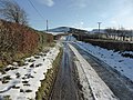
 Icy lane - geograph.org.uk - 4299154.jpg 1,600 × 1,200; 480 KB
-
 Icy lane near Blaen-y-nant - geograph.org.uk - 4299166.jpg 1,600 × 1,155; 491 KB
-
 Icy lane near Cefn Berain - geograph.org.uk - 4299126.jpg 1,600 × 1,200; 461 KB
-
 Icy lane near Cefn Berain - geograph.org.uk - 4299132.jpg 1,600 × 1,200; 569 KB
-
 Junction of minor roads at Tal-y-byn - geograph.org.uk - 5982881.jpg 4,000 × 3,000; 3.45 MB
-
 Lane and fields near Cae Newydd - geograph.org.uk - 4299208.jpg 1,600 × 1,200; 468 KB
-
 Lane and hills - geograph.org.uk - 124514.jpg 640 × 480; 58 KB
-
 Lazy Sunday near Llannefydd - geograph.org.uk - 157460.jpg 640 × 480; 73 KB
-
 Line of trees near Llannefydd - geograph.org.uk - 1901258.jpg 2,592 × 1,944; 2.52 MB
-
 Llanefydd recycling area, on the car park - geograph.org.uk - 4299104.jpg 1,600 × 1,200; 326 KB
-
 Llanefydd village hall, car park ^ phone box - geograph.org.uk - 4299106.jpg 1,600 × 1,200; 380 KB
-
 Llannefydd - geograph.org.uk - 124506.jpg 640 × 480; 63 KB
-
 Llannefydd - geograph.org.uk - 124507.jpg 640 × 480; 74 KB
-
 Llannefydd fields - geograph.org.uk - 157454.jpg 640 × 480; 101 KB
-
 Llannefydd geograph-3473361-by-Ben-Brooksbank.jpg 2,394 × 1,607; 3.09 MB
-
 Llannefydd Parish Hall - geograph.org.uk - 784968.jpg 640 × 480; 59 KB
-

-
 Looking across the valley to Derm - geograph.org.uk - 4299192.jpg 1,600 × 1,200; 477 KB
-
 Looking over Plâs-uchaf reservoir to Mynydd y Gaer - geograph.org.uk - 4297435.jpg 1,600 × 1,200; 457 KB
-
 Looking towards Dolwen reservoir - geograph.org.uk - 4300316.jpg 1,600 × 1,200; 440 KB
-
 Looking towards Groesffordd Farm - geograph.org.uk - 6017084.jpg 4,000 × 3,000; 2.26 MB
-
 Looking towards Ochor y gaer - geograph.org.uk - 4299093.jpg 1,600 × 1,160; 380 KB
-
 Looking towards Plas Cwtta - geograph.org.uk - 4299199.jpg 1,600 × 1,200; 298 KB
-
 Minor road near Mynydd y Girt - geograph.org.uk - 4300665.jpg 1,600 × 1,147; 241 KB
-
 Mynydd y Gaer - geograph.org.uk - 783002.jpg 640 × 480; 90 KB
-
 Mynydd y Gaer - geograph.org.uk - 783006.jpg 640 × 480; 94 KB
-
 Mynydd y Gaer 620344.jpg 640 × 480; 84 KB
-

-

-
 Part of the Afon Elwy - geograph.org.uk - 1966825.jpg 640 × 480; 128 KB
-
 Part of the Elwy valley - geograph.org.uk - 1966871.jpg 640 × 480; 70 KB
-
 Pen-y-bryn - geograph.org.uk - 4177571.jpg 800 × 531; 181 KB
-
 Plas Uchaf - geograph.org.uk - 784337.jpg 640 × 424; 57 KB
-
 Plas Uchaf Reservoir - geograph.org.uk - 784333.jpg 640 × 480; 116 KB
-
 Plas-uchaf farm near Mynydd y Gaer - geograph.org.uk - 1966877.jpg 640 × 480; 112 KB
-
 Plas-uchaf Reservoir - geograph.org.uk - 1966880.jpg 640 × 480; 137 KB
-
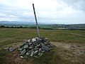
 Pole and cairn on Mynydd y Gaer - geograph.org.uk - 1966728.jpg 640 × 480; 66 KB
-

-
 Pumping Station - geograph.org.uk - 4178964.jpg 800 × 531; 158 KB
-
 Road bridge crossing Dyffryn Aled - geograph.org.uk - 4179725.jpg 800 × 531; 193 KB
-
 Road junction - geograph.org.uk - 3050831.jpg 640 × 483; 84 KB
-
 Road junction in Cefn Berain - geograph.org.uk - 4176007.jpg 800 × 531; 159 KB
-
 Road junction near Henllan - geograph.org.uk - 4998983.jpg 3,089 × 2,048; 3.13 MB
-
 Road junction near Mynydd y Gaer - geograph.org.uk - 4299089.jpg 1,600 × 1,200; 729 KB
-

-
 Rough grazing - geograph.org.uk - 4179729.jpg 800 × 531; 136 KB
-
 Seafront walkway - geograph.org.uk - 6855474.jpg 1,600 × 1,063; 374 KB
-
 Sheep on Fron Fawr, near Llanefydd - geograph.org.uk - 784862.jpg 520 × 640; 82 KB
-
 Side valley above Dyffryn Aled - geograph.org.uk - 4177567.jpg 800 × 531; 149 KB
-
 Snowdonia from Moel Fodiar - geograph.org.uk - 4189790.jpg 1,024 × 768; 162 KB
-
 Snowy field near Cefn Berain - geograph.org.uk - 4299128.jpg 1,600 × 1,200; 539 KB
-
 Snowy field on Mynydd y Girt - geograph.org.uk - 4300320.jpg 1,600 × 1,200; 492 KB
-

-
 Striped ready for spring - geograph.org.uk - 157464.jpg 640 × 480; 48 KB
-
 Summit of Mynydd y Gaer - geograph.org.uk - 1966737.jpg 640 × 480; 65 KB
-
 Swing over the River Elwy - geograph.org.uk - 1966782.jpg 640 × 480; 134 KB
-
 Thatched house, Llanefydd NLW3363912.jpg 595 × 426; 53 KB
-
 The crossroads near Blaen-y-nant - geograph.org.uk - 4299162.jpg 1,600 × 1,200; 558 KB
-
 The crossroads near Cefn Berain - geograph.org.uk - 4299121.jpg 1,600 × 1,200; 307 KB
-
 The Dyffryn Aled valley - geograph.org.uk - 4178959.jpg 800 × 531; 149 KB
-
 The Hawk and Buckle - geograph.org.uk - 125109.jpg 640 × 480; 72 KB
-
 The lane to Plâs-uchaf - geograph.org.uk - 4299083.jpg 1,600 × 1,200; 589 KB
-
 The Llanefydd to Henllan road - geograph.org.uk - 784971.jpg 640 × 480; 67 KB
-
 The road junction at Ffynhonnau Farm - geograph.org.uk - 4300656.jpg 1,600 × 1,200; 302 KB
-
 The road to Llanefydd - geograph.org.uk - 4299099.jpg 1,600 × 1,200; 416 KB
-
 The southern half of Plâs-uchaf reservoir - geograph.org.uk - 4299085.jpg 1,600 × 1,200; 228 KB
-
 The steep lane down to the Afon Aled - geograph.org.uk - 4300681.jpg 1,600 × 1,200; 556 KB
-
 Trees in a fence - geograph.org.uk - 4177561.jpg 1,024 × 680; 225 KB
-
 Ty-gwyn and Fron Fawr - geograph.org.uk - 4178954.jpg 800 × 531; 149 KB
-
 View across the Vale of Clwyd - geograph.org.uk - 4176023.jpg 800 × 531; 124 KB
-
 View across the Vale of Clwyd - geograph.org.uk - 4177533.jpg 800 × 531; 146 KB
-
 View from the summit of Mynydd y Gaer - geograph.org.uk - 783015.jpg 640 × 480; 52 KB
-
 View to Fron Fawr - geograph.org.uk - 4178952.jpg 800 × 531; 166 KB
-
 View to Moel Fodiar - geograph.org.uk - 4176017.jpg 1,024 × 680; 395 KB
-
 View to Moel Fodiar - geograph.org.uk - 4177536.jpg 800 × 531; 128 KB
-
 View to the Irish Sea - geograph.org.uk - 4177542.jpg 800 × 531; 142 KB
-
-
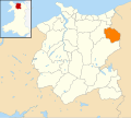 Wales Conwy Community Llannefydd map.svg 512 × 458; 612 KB
-
 Waterlogged fields near Pen-y-coed - geograph.org.uk - 4297417.jpg 1,600 × 1,200; 377 KB
-
 Waterlogged gateway ^ fields near Llanefydd - geograph.org.uk - 4299113.jpg 1,600 × 1,200; 379 KB
-
 Wind turbine above Bont-Newydd - geograph.org.uk - 4169915.jpg 531 × 800; 123 KB
-
 Wood anemone (Anemone nemorosa) - geograph.org.uk - 784975.jpg 640 × 493; 95 KB
-

-
 Y Cneifwyr.jpg 1,600 × 1,041; 304 KB
-
 Yew trees, Llannefydd churchyard - geograph.org.uk - 6021827.jpg 4,000 × 3,000; 2.46 MB


_-_geograph.org.uk_-_5173709.jpg)


_-_geograph.org.uk_-_2185304.jpg)


_-_geograph.org.uk_-_784975.jpg)


