Category:Llanthony provender mill
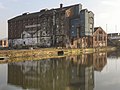
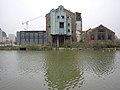
Llanthony provender mill, Gloucester Docks. Burned and destroyed by arson, 2015, rebuilt as flats 2018.
This is a category about listed building number 1271710. |
| Object location | | View all coordinates using: OpenStreetMap |
|---|
mill building in Gloucester, Gloucestershire, England, UK  | |||||
| Upload media | |||||
| Instance of |
| ||||
|---|---|---|---|---|---|
| Location | Gloucester, Gloucestershire, South West England, England | ||||
| Heritage designation |
| ||||
 | |||||
Media in category "Llanthony provender mill"
The following 26 files are in this category, out of 26 total.
-
 Derelict Warehouse, High Orchard.jpg 640 × 480; 388 KB
-
 DerelictDocks2.JPG 1,534 × 1,823; 2.63 MB
-
 DerelictDocks3.JPG 2,016 × 1,344; 1.11 MB
-

-
 Disused warehouse, Gloucester Docks - geograph.org.uk - 1469401.jpg 640 × 480; 114 KB
-
 Disused warehouse, Gloucester Docks - geograph.org.uk - 1471943.jpg 640 × 480; 108 KB
-
 Downings Malthouse and Llanthony Provender warehouse.jpg 4,096 × 3,072; 1.53 MB
-
 Llanthony mill. - geograph.org.uk - 1846906.jpg 4,000 × 3,000; 1.67 MB
-
 Llanthony Provender Mill and the Gloucester&Sharpness Canal in July 2010.jpg 4,000 × 3,000; 2.64 MB
-
 Llanthony Provender Mill April 2019 01.jpg 4,096 × 3,072; 1.47 MB
-
 Llanthony Provender Mill April 2019 02.jpg 4,096 × 3,072; 1.88 MB
-
 Llanthony Provender Mill April 2019 03.jpg 4,096 × 3,072; 2.11 MB
-
 Llanthony Provender Mill April 2019 04.jpg 4,096 × 3,072; 2.3 MB
-
 Llanthony Provender Mill April 2019 05.jpg 5,187 × 2,559; 1.97 MB
-
 Llanthony Provender Mill April 2019 06.jpg 4,096 × 3,072; 1.79 MB
-
 Llanthony Provender Mill April 2019 07.jpg 4,096 × 3,072; 2.07 MB
-
 Llanthony Provender Mill building in July 2011 (2).jpg 2,000 × 1,500; 868 KB
-
 Llanthony Provender Mill building in July 2011.jpg 1,500 × 2,000; 652 KB
-
 Llanthony Provender Mill buildings in April 2010.jpg 4,000 × 3,000; 3.6 MB
-
 Llanthony Provender Mill buildings in July 2010.jpg 4,000 × 3,000; 3.36 MB
-
 Llanthony Provender Mill in 2008.jpg 2,592 × 1,944; 1.59 MB
-
 Llanthony Provender Mill in 2019 after redevelopment (2).jpg 4,592 × 3,448; 2.99 MB
-
 Llanthony Provender Mill in 2019 after redevelopment.jpg 4,472 × 2,516; 2.46 MB
-
 Llanthony Provender Mill in January 2016.jpg 4,592 × 3,448; 3.29 MB
-
 Llanthony Wharf - geograph.org.uk - 3575913.jpg 2,304 × 1,704; 1.48 MB
-
 What now for the future^ - geograph.org.uk - 3567450.jpg 2,304 × 1,704; 1.65 MB


.jpg)


.jpg)


