Category:Location maps of provinces of the Netherlands
Media in category "Location maps of provinces of the Netherlands"
The following 13 files are in this category, out of 13 total.
-
 Netherlands Drenthe location map.svg 861 × 1,000; 87 KB
-
 Netherlands Flevoland location map.svg 956 × 1,000; 150 KB
-
 Netherlands Friesland location map.svg 1,000 × 914; 171 KB
-
 Netherlands Gelderland location map.svg 1,000 × 698; 162 KB
-
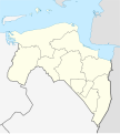 Netherlands Groningen location map.svg 899 × 1,000; 94 KB
-
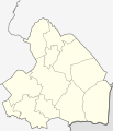
 Netherlands Limburg location map.svg 470 × 1,000; 78 KB
-
 Netherlands North Brabant location map.svg 1,000 × 563; 244 KB
-
 Netherlands North Holland location map.svg 607 × 1,000; 233 KB
-
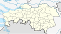
 Netherlands Overijssel location map.svg 948 × 1,000; 203 KB
-
 Netherlands South Holland location map.svg 1,000 × 928; 274 KB
-
 Netherlands Utrecht location map.svg 1,002 × 817; 84 KB
-
 Netherlands Utrecht –2019 location map.svg 1,000 × 815; 75 KB
-
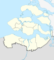 Netherlands Zeeland location map.svg 890 × 1,000; 262 KB


