Category:Locator maps of Folketing constituencies
Media in category "Locator maps of Folketing constituencies"
The following 20 files are in this category, out of 20 total.
-
 Bornholm (Folketing constituency).svg 2,500 × 3,000; 128 KB
-
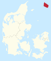
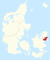
 Bornholms Storkreds.svg 510 × 412; 541 KB
-
 Copenhagen (Folketing constituency).svg 2,500 × 3,000; 128 KB
-
 East Jutland (Folketing constituency).svg 2,500 × 3,000; 129 KB
-
 Funen (Folketing constituency).svg 2,500 × 3,000; 128 KB
-
 Fyns Storkreds.svg 510 × 412; 541 KB
-
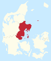
 Greater Copenhagen (Folketing constituency).svg 2,500 × 3,000; 129 KB
-
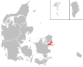 København Omegns Storkreds.svg 510 × 412; 541 KB
-
 Københavns Storkreds.svg 510 × 412; 541 KB
-
 Nordjyllands Storkreds.svg 510 × 412; 541 KB
-
 Nordsjællands Storkreds.svg 510 × 412; 541 KB
-
 North Jutland (Folketing constituency).svg 2,500 × 3,000; 128 KB
-
 North Zealand (Folketing constituency).svg 2,500 × 3,000; 128 KB
-
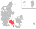
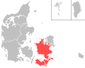 Sjællands Storkreds.svg 510 × 412; 541 KB
-
 South Jutland (Folketing constituency).svg 2,500 × 3,000; 129 KB
-
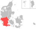 Sydjyllands Storkreds.svg 510 × 412; 541 KB
-
 Vestjyllands Storkreds.svg 510 × 412; 541 KB
-
 West Jutland (Folketing constituency).svg 2,500 × 3,000; 129 KB
-
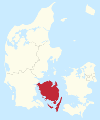
 Zealand (Folketing constituency).svg 2,500 × 3,000; 129 KB
-
 Østjyllands Storkreds.svg 510 × 412; 541 KB
.svg)

.svg)
.svg)
.svg)

.svg)


.svg)
.svg)

.svg)


.svg)
.svg)
