Category:Locator maps of arrondissements of Eure-et-Loir to 2018
Media in category "Locator maps of arrondissements of Eure-et-Loir to 2018"
The following 4 files are in this category, out of 4 total.
-
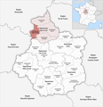
 Locator map of Arrondissement Chartres 2018.png 2,500 × 2,585; 1.5 MB
-
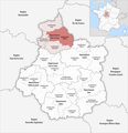
 Locator map of Arrondissement Châteaudun 2018.png 2,500 × 2,585; 1.5 MB
-
 Locator map of Arrondissement Dreux 2018.png 2,500 × 2,585; 1.5 MB
-
 Locator map of Arrondissement Nogent-le-Rotrou 2018.png 2,500 × 2,585; 1.5 MB


