Category:Locator maps of arrondissements of Puy-de-Dôme to 2016
Media in category "Locator maps of arrondissements of Puy-de-Dôme to 2016"
The following 10 files are in this category, out of 10 total.
-
 Locator map of Arrondissement Ambert 2016.png 2,500 × 1,995; 1.53 MB
-
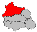
 Locator map of Arrondissement Clermont-Ferrand 2016.png 2,500 × 1,995; 1.53 MB
-
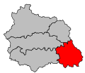
 Locator map of Arrondissement Issoire 2016.png 2,500 × 1,995; 1.53 MB
-
 Map arrondissement code 631.svg 527 × 455; 7 KB
-
 Map arrondissement code 632.svg 527 × 455; 7 KB
-
 Map arrondissement code 633.svg 527 × 455; 7 KB
-
 Map arrondissement code 634.svg 527 × 455; 7 KB
-
 Map arrondissement code 635.svg 527 × 455; 7 KB
-
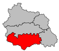
 Locator map of Arrondissement Riom 2016.png 2,500 × 1,995; 1.53 MB
-
 Locator map of Arrondissement Thiers 2016.png 2,500 × 1,995; 1.53 MB


