Category:Locator maps of communes in Mayotte
Administrative regions and territorial collectivity of Metropolitan France (‡ since start of 2016):
Auvergne-Rhône-Alpes‡ · Bourgogne-Franche-Comté‡ · Brittany · Centre-Val de Loire · Corsica · Grand Est‡ · Hauts-de-France‡ · Île-de-France · Normandy‡ · New Aquitaine‡ · Occitania‡ · Pays de la Loire · Provence-Alpes-Côte d'Azur
Former administrative regions of Metropolitan France (until end of 2015):
Alsace · Nord-Pas-de-Calais · Lower Normandy · Upper Normandy
Overseas departments and regions: Guadeloupe · Martinique · French Guiana · Réunion · Mayotte
Sui generis territories: New Caledonia
Departments of Metropolitan France: Ain [01] · Alpes-Maritimes [06] · Ardèche [07] · Aude [11] · Bouches-du-Rhône [13] · Charente-Maritime [17] · Corse-du-Sud [2A]† · Haute-Corse [2B]† · Côtes-d'Armor [22] · Eure-et-Loir [28] · Finistère [29] · Gard [30] · Haute-Garonne [31] · Gers [32] · Gironde [33] · Ille-et-Vilaine [35] · Indre [36] · Indre-et-Loire [37] · Landes [40] · Loire-Atlantique [44] · Lot-et-Garonne [47] · Marne [51] · Morbihan [56] · Nord [59] · Pas-de-Calais [62] · Pyrénées-Atlantiques [64] · Pyrénées-Orientales [66] · Bas-Rhin [67] · Haut-Rhin [68] · Savoie [73] · Paris [75] · Yvelines [78] · Somme [80] · Var [83] · Haute-Vienne [87] · Vosges [88] · Territoire de Belfort [90] · Essonne [91] · Hauts-de-Seine [92] · Seine-Saint-Denis [93] · Val-de-Marne [94]
Overseas departments and regions: Guadeloupe [971] · Martinique [972] · French Guiana [973] · Réunion [974] · Mayotte [976]
Sui generis territories: New Caledonia [988]
Overseas departments and regions: Guadeloupe [971] · Martinique [972] · French Guiana [973] · Réunion [974] · Mayotte [976]
Sui generis territories: New Caledonia [988]
Media in category "Locator maps of communes in Mayotte"
The following 25 files are in this category, out of 25 total.
-
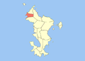
 Locator map of Acoua 2018.png 3,500 × 4,371; 696 KB
-
 Acoua.png 670 × 481; 24 KB
-
 Locator map of Bandraboua 2018.png 3,500 × 4,371; 697 KB
-
 Locator map of Bandrele 2018.png 3,500 × 4,371; 697 KB
-
 Locator map of Bouéni 2018.png 3,500 × 4,371; 696 KB
-
 Locator map of Chiconi 2018.png 3,500 × 4,371; 696 KB
-
 Locator map of Chirongui 2018.png 3,500 × 4,371; 697 KB
-
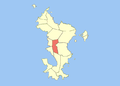
 Locator map of Dembeni 2018.png 3,500 × 4,371; 696 KB
-
 Locator map of Dzaoudzi 2018.png 3,500 × 4,371; 696 KB
-
 Dzaoudzi.png 670 × 481; 7 KB
-
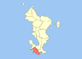
 Locator map of Kani-Kéli 2018.png 3,500 × 4,371; 696 KB
-
 Kani-Kéli.png 670 × 481; 23 KB
-
 Locator map of Koungou 2018.png 3,500 × 4,371; 697 KB
-
 Locator map of Bandraboua.png 670 × 481; 24 KB
-
 Locator map of Ouangani.png 670 × 481; 23 KB
-
 Locator map of M'Tsangamouji 2018.png 3,500 × 4,371; 697 KB
-
 Locator map of Mamoudzou 2018.png 3,500 × 4,371; 697 KB
-
 Mamoudzou.png 670 × 481; 24 KB
-
 Locator map of Mtsamboro 2018.png 3,500 × 4,371; 696 KB
-
 Mtsamboro Commune.png 670 × 481; 24 KB
-
 Locator map of Ouangani 2018.png 3,500 × 4,371; 696 KB
-
 Locator map of Pamandzi 2018.png 3,500 × 4,371; 696 KB
-
 Pamandzi.png 670 × 481; 23 KB
-
 Locator map of Sada 2018.png 3,500 × 4,371; 696 KB
-
 Locator map of Tsingoni 2018.png 3,500 × 4,371; 697 KB


