Category:Locator maps of districts in Saxony (gray scheme)
Federal states of Germany:
Subcategories
This category has the following 2 subcategories, out of 2 total.
Media in category "Locator maps of districts in Saxony (gray scheme)"
The following 15 files are in this category, out of 15 total.
-
 Landkreise in Sachsen.png 448 × 347; 11 KB
-
 Sachsen Kreise (grau).svg 2,068 × 1,508; 128 KB
-
 Saxony BZ.svg 2,268 × 1,814; 1.28 MB
-
 Saxony C.svg 2,268 × 1,814; 788 KB
-
 Saxony DD.svg 2,268 × 1,814; 1.28 MB
-
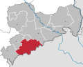 Saxony ERZ.svg 2,268 × 1,814; 1.28 MB
-
 Saxony FG.svg 2,268 × 1,814; 1.28 MB
-
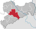
 Saxony GR.svg 2,268 × 1,814; 1.28 MB
-
 Saxony L (City).svg 2,268 × 1,814; 1.28 MB
-
 Saxony L (District).svg 2,268 × 1,814; 1.28 MB
-
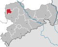
 Saxony MEI.svg 2,268 × 1,814; 1.28 MB
-
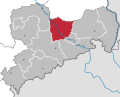
 Saxony PIR.svg 2,268 × 1,814; 1.28 MB
-
 Saxony TDO.svg 2,268 × 1,814; 1.28 MB
-
 Saxony V.svg 2,268 × 1,814; 1.28 MB
-
 Saxony Z.svg 2,268 × 1,814; 1.28 MB

.svg)


.svg)
.svg)


