Category:Locator maps of former area municipalities in Saxony-Anhalt
Federal states of Germany:
Media in category "Locator maps of former area municipalities in Saxony-Anhalt"
The following 18 files are in this category, out of 18 total.
-
 VG Arneburg-Goldbeck in SDL.png 299 × 299; 6 KB
-
 VG Bad Dürrenberg in SK.png 299 × 266; 6 KB
-
 VG Bad Lauchstädt in SK.png 299 × 266; 6 KB
-
 VG Biederitz-Möser in JL.png 299 × 299; 6 KB
-
 VG Bismark-Kläden in SDL.png 299 × 299; 6 KB
-
 VG Elbe-Havel-Land in SDL.png 299 × 299; 6 KB
-
 VG Elbe-Stremme-Fiener in JL.png 299 × 299; 6 KB
-
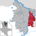
 VG Genthin in JL.png 299 × 299; 6 KB
-
 VG Götschetal-Petersberg in SK.png 299 × 266; 6 KB
-
 VG Leuna-Kötzschau in SK.png 299 × 266; 6 KB
-
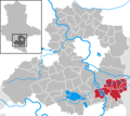
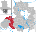
 VG Merseburg in SK.png 299 × 266; 6 KB
-
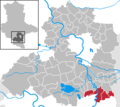
 VG Oberes Geiseltal in SK.png 299 × 266; 6 KB
-
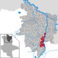
 VG Osterburg in SDL.png 299 × 299; 6 KB
-
 VG Seehausen (Altmark) in SDL.png 299 × 299; 6 KB
-
 VG Stendal-Uchtetal in SDL.png 299 × 299; 6 KB
-
 VG Tangermünde in SDL.png 299 × 299; 6 KB
-
 VG Weida-Land.png 299 × 266; 6 KB
-
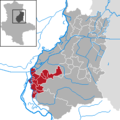
 VG Westlicher Saalkreis in SK.png 299 × 266; 6 KB


_in_SDL.png)


