Category:Locator maps of parliamentary constituencies of Cambridgeshire
Maps of Parliamentary constituencies in Cambridgeshire.
Media in category "Locator maps of parliamentary constituencies of Cambridgeshire"
The following 18 files are in this category, out of 18 total.
-
 Cambridge2007Constituency.svg 211 × 245; 124 KB
-
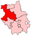
 CambridgeConstituency.svg 201 × 235; 42 KB
-
 CambridgeshireParliamentaryConstituencies2007.svg 211 × 245; 78 KB
-
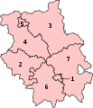 CambridgeshireParliamentaryConstituenciesNumbered.svg 201 × 235; 46 KB
-
 Huntingdon2007Constituency.svg 211 × 245; 124 KB
-
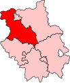
 HuntingdonConstituency.svg 201 × 235; 42 KB
-
 Newmarket1885.png 377 × 500; 15 KB
-
 NorthEastCambridgeshire2007Constituency.svg 211 × 245; 124 KB
-
 NorthEastCambridgeshireConstituency.svg 201 × 235; 42 KB
-
 NorthWestCambridgeshire2007Constituency.svg 211 × 245; 124 KB
-
 NorthWestCambridgeshireConstituency.svg 201 × 235; 42 KB
-
 Peterborough2007Constituency.svg 211 × 245; 124 KB
-
 PeterboroughConstituency.svg 201 × 235; 42 KB
-
 SouthCambridgeshire2007Constituency.svg 211 × 245; 124 KB
-
 SouthCambridgeshireConstituency.svg 201 × 235; 42 KB
-
 SouthEastCambridgeshire2007Constituency.svg 211 × 245; 124 KB
-
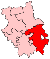
 SouthEastCambridgeshireConstituency.svg 201 × 235; 42 KB
-
 SouthWestCambridgeshire1983Constituency.svg 75 × 82; 8 KB


