Category:Locator maps of populated places in Monmouth County, New Jersey
Media in category "Locator maps of populated places in Monmouth County, New Jersey"
The following 51 files are in this category, out of 51 total.
-
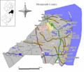
 Aberdeen twp nj 025.png 680 × 580; 65 KB
-
 Avon by the sea nj 025.png 680 × 580; 64 KB
-
 Colts neck twp nj 025.png 680 × 580; 66 KB
-
 Freehold nj 025.png 680 × 580; 64 KB
-
 Freehold twp nj 025.png 680 × 580; 67 KB
-
 Hazlet twp nj 025.png 680 × 580; 65 KB
-
 Holmdel twp nj 025.png 680 × 580; 66 KB
-
 Howell twp nj 025.png 680 × 580; 67 KB
-
 Manalapan twp nj 025.png 680 × 580; 67 KB
-
 Marlboro twp nj 025.png 680 × 580; 67 KB
-
 Middletown twp nj 025.png 680 × 580; 66 KB
-

-

-

-

-

-

-

-

-

-

-

-

-
-

-

-

-

-

-
-
-

-

-

-

-

-

-

-

-

-

-

-
-
-
-

-
 Neptune twp nj 025.png 680 × 580; 66 KB
-
 Ocean twp nj 025.png 680 × 580; 66 KB
-
 Shrewsbury twp nj 025.png 680 × 580; 65 KB
-
 Upper freehold twp nj 025.png 680 × 580; 67 KB
-
 Wall twp nj 025.png 680 × 580; 67 KB


