Category:Locator maps of territories of the Holy Roman Empire (1618)
Media in category "Locator maps of territories of the Holy Roman Empire (1618)"
The following 32 files are in this category, out of 32 total.
-
 Locator Anhalt within the Holy Roman Empire (1618).svg 2,769 × 2,524; 1,024 KB
-
 Locator Bamberg within the Holy Roman Emire (1618).svg 2,769 × 2,524; 1,024 KB
-
 Locator Bavaria within the Holy Roman Empire (1618).svg 2,769 × 2,524; 1,024 KB
-
 Locator Bayreuth within the Holy Roman Emire (1618).svg 2,769 × 2,524; 1,024 KB
-
 Locator Bishopric of Münster within the Holy Roman Empire (1610).svg 2,769 × 2,524; 1,024 KB
-
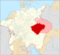 Locator Bohemia within the Holy Roman Empire (1618).svg 2,769 × 2,524; 1,021 KB
-
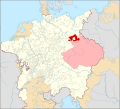
 Locator Brandenburg within the Holy Roman Empire (1618).svg 2,769 × 2,524; 1,024 KB
-
 Locator Brandenburg-Prussia within the Holy Roman Empire (1618).svg 2,769 × 2,524; 1,024 KB
-
 Locator Bremen (archbishopric) within the Holy Roman Emire (1618).svg 2,769 × 2,524; 1,024 KB
-
 Locator Brunswick-Lüneburg within the Holy Roman Emire (1618).svg 2,769 × 2,524; 1,024 KB
-
 Locator Brunswick-Wolfenbüttel within the Holy Roman Emire (1618).svg 2,769 × 2,524; 1,024 KB
-
 Locator Danish share of Schleswig-Holstein within the Holy Roman Emire (1618).svg 2,769 × 2,524; 1.01 MB
-
 Locator Electoral Cologne within the Holy Roman Emire (1618).svg 2,769 × 2,524; 1,024 KB
-
 Locator Electoral Palatinate within the Holy Roman Empire (1618).svg 2,769 × 2,524; 1 MB
-
 Locator Electoral Saxony within the Holy Roman Empire (1618).svg 2,769 × 2,524; 1 MB
-
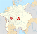
 Locator Electorates within the Holy Roman Empire (1618).png 2,769 × 2,524; 2.38 MB
-
 Locator Electorates within the Holy Roman Empire in 1618 (alternate version).svg 2,215 × 2,019; 3.26 MB
-
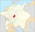
 Locator Hesse-Kassel within the Holy Roman Emire (1618).svg 2,769 × 2,524; 1,024 KB
-
 Locator Lands of the Bohemian Crown within the Holy Roman Empire (1618).svg 2,769 × 2,524; 1,024 KB
-
 Locator Lower Lusatia within the Holy Roman Empire (1618).svg 2,769 × 2,524; 1,024 KB
-
 Locator Mainz within the Holy Roman Emire (1618).svg 2,769 × 2,524; 1,024 KB
-
 Locator Mecklenburg within the Holy Roman Empire (1618).svg 2,769 × 2,524; 1,024 KB
-
 Locator Moravia within the Holy Roman Empire (1618).svg 2,769 × 2,524; 1,024 KB
-
 Locator Pomerania-Stettin within the Holy Roman Emire (1618).svg 2,769 × 2,524; 1,024 KB
-
 Locator Salzburg within the Holy Roman Emire (1618).svg 2,769 × 2,524; 1,024 KB
-
 Locator Schleswig-Holstein-Gottorp within the Holy Roman Emire (1618).svg 2,769 × 2,524; 1.01 MB
-
 Locator Silesia within the Holy Roman Empire (1618).svg 2,769 × 2,524; 1,021 KB
-
 Locator Upper Lusatia within the Holy Roman Empire (1618).svg 2,769 × 2,524; 1,024 KB
-
 Locator Württemberg within the Holy Roman Emire (1618).svg 2,769 × 2,524; 1,024 KB
-
 Locator Würzburg within the Holy Roman Emire (1618).svg 2,769 × 2,524; 1,024 KB
-
 Locator Pomerania-Wolgast within the Holy Roman Emire (1618).svg 2,769 × 2,524; 1,024 KB
-
 金印勅書により選帝侯領になった領邦.png 658 × 600; 310 KB
.svg)
.svg)
.svg)
.svg)
.svg)
.svg)
.svg)
.svg)
_within_the_Holy_Roman_Emire_(1618).svg)
.svg)
.svg)
.svg)
.svg)
.svg)
.svg)
.png)
.svg)
.svg)
.svg)
.svg)
.svg)
.svg)
.svg)
.svg)
.svg)
.svg)
.svg)
.svg)
.svg)
.svg)
.svg)
