Category:Locator maps of wards in the East Riding of Yorkshire
Subcategories
This category has only the following subcategory.
Media in category "Locator maps of wards in the East Riding of Yorkshire"
The following 27 files are in this category, out of 27 total.
-
 Beverley Rural East Riding of Yorkshire ward map 2010.svg 1,425 × 1,107; 1.05 MB
-
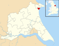
 Bridlington Central and Old Town East Riding of Yorkshire ward map 2010.svg 1,425 × 1,107; 1.05 MB
-
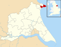 Bridlington North East Riding of Yorkshire ward map 2010.svg 1,425 × 1,107; 1.05 MB
-
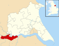
 Bridlington South East Riding of Yorkshire ward map 2010.svg 1,425 × 1,107; 1.05 MB
-
 Cottingham North East Riding of Yorkshire ward map 2010.svg 1,425 × 1,107; 1.05 MB
-
 Cottingham South East Riding of Yorkshire ward map 2010.svg 1,425 × 1,107; 1.05 MB
-
 Dale East Riding of Yorkshire ward map 2010.svg 1,425 × 1,107; 1.05 MB
-
 Driffield and Rural East Riding of Yorkshire ward map 2010.svg 1,425 × 1,107; 1.05 MB
-
 East Riding of Yorkshire Council UK ward map 2010 annotated.svg 1,425 × 1,107; 1.06 MB
-
 East Wolds and Coastal East Riding of Yorkshire ward map 2010.svg 1,425 × 1,107; 1.05 MB
-
 Goole North East Riding of Yorkshire ward map 2010.svg 1,425 × 1,107; 1.05 MB
-
 Goole South East Riding of Yorkshire ward map 2010.svg 1,425 × 1,107; 1.05 MB
-
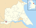
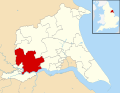
 Hessle East Riding of Yorkshire ward map 2010.svg 1,425 × 1,107; 1.05 MB
-
 Howden East Riding of Yorkshire ward map 2010.svg 1,425 × 1,107; 1.05 MB
-
 Howdenshire East Riding of Yorkshire ward map 2010.svg 1,425 × 1,107; 1.05 MB
-
 Mid Holderness East Riding of Yorkshire ward map 2010.svg 1,425 × 1,107; 1.05 MB
-
 Minster and Woodmansey East Riding of Yorkshire ward map 2010.svg 1,425 × 1,107; 1.05 MB
-
 North Holderness East Riding of Yorkshire ward map 2010.svg 1,425 × 1,107; 1.05 MB
-
 Pocklington Provincial East Riding of Yorkshire ward map 2010.svg 1,425 × 1,107; 1.05 MB
-
 Snaith, Airmyn, Rawcliffe and Marshland East Riding of Yorkshire ward map 2010.svg 1,425 × 1,107; 1.05 MB
-
 South East Holderness East Riding of Yorkshire ward map 2010.svg 1,425 × 1,107; 1.05 MB
-
 South Hunsley East Riding of Yorkshire ward map 2010.svg 1,425 × 1,107; 1.05 MB
-
 South West Holderness East Riding of Yorkshire ward map 2010.svg 1,425 × 1,107; 1.05 MB
-
 St Mary's East Riding of Yorkshire ward map 2010.svg 1,425 × 1,107; 1.05 MB
-
 Tranby East Riding of Yorkshire ward map 2010.svg 1,425 × 1,107; 1.05 MB
-
 Willerby and Kirk Ella East Riding of Yorkshire ward map 2010.svg 1,425 × 1,107; 1.05 MB
-
 Wolds Weighton East Riding of Yorkshire ward map 2010.svg 1,425 × 1,107; 1.05 MB


