Category:Long Island High School (Long Island, Kansas)
| Object location | | View all coordinates using: OpenStreetMap |
|---|
|
This is a category about a place or building that is listed on the National Register of Historic Places in the United States of America. Its reference number is 05000551. |
_from_SE_1.JPG) | |||||
| Upload media | |||||
| Instance of | |||||
|---|---|---|---|---|---|
| Location | Long Island, Phillips County, Kansas | ||||
| Street address |
| ||||
 | |||||
Now operated by Northern Valley Schools.
Media in category "Long Island High School (Long Island, Kansas)"
The following 6 files are in this category, out of 6 total.
-
 Northern Valley school (Long Island, KS) from E 1.JPG 2,328 × 1,656; 606 KB
-
 Northern Valley school (Long Island, KS) from N 1.JPG 2,211 × 943; 411 KB
-
 Northern Valley school (Long Island, KS) from NE 1.JPG 2,397 × 1,688; 856 KB
-
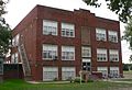 Northern Valley school (Long Island, KS) from SE 1.JPG 2,215 × 1,519; 730 KB
-
 Northern Valley school (Long Island, KS) N fire escape 1.JPG 1,616 × 2,255; 933 KB
-
 Northern Valley school (Long Island, KS) S fire escape 1.JPG 1,490 × 2,194; 942 KB
_from_E_1.JPG)
_from_N_1.JPG)
_from_NE_1.JPG)
_N_fire_escape_1.JPG)
_S_fire_escape_1.JPG)