Category:Longley, Calderdale
Subcategories
This category has the following 5 subcategories, out of 5 total.
D
- Dodge Royd Lane (4 F)
- Doldram Lane (8 F)
S
- Stansfield Mill Lane (16 F)
Media in category "Longley, Calderdale"
The following 101 files are in this category, out of 101 total.
-
 98 Sowerby Bridge Footpath 136 in Longley Wood, Norland - geograph.org.uk - 2931986.jpg 2,000 × 1,463; 1.06 MB
-
 A gated stile, Norland - geograph.org.uk - 4881261.jpg 2,048 × 1,536; 1.05 MB
-
 A happy couple at Butterworth, Norland - geograph.org.uk - 3119534.jpg 2,000 × 1,500; 1 MB
-
 A muddy section of Sowerby Bridge Footpath 135 - geograph.org.uk - 2930276.jpg 2,000 × 1,500; 1.39 MB
-
 Bridge on Sowerby Bridge Footpath 136 - geograph.org.uk - 2930385.jpg 2,000 × 1,472; 1.32 MB
-
 Bridge over the disused Rishworth branch line - geograph.org.uk - 3966635.jpg 2,000 × 1,442; 1.32 MB
-
 Bridge over the old railway near Dodge Royd Wood - geograph.org.uk - 3104590.jpg 2,048 × 1,536; 534 KB
-
 Bungalows at Ladstone Park Caravan Site, Norland - geograph.org.uk - 3119529.jpg 2,000 × 1,489; 1.15 MB
-
 Buttercup Lane at Dodge Royd, Norland - geograph.org.uk - 2932085.jpg 1,500 × 2,000; 1.28 MB
-
 Buttercup Lane, Norland - geograph.org.uk - 2932070.jpg 2,000 × 1,500; 1.19 MB
-
 Car park on the edge of Norland Moor - geograph.org.uk - 3119615.jpg 2,000 × 1,482; 921 KB
-
 Cattle diet supplement dispenser on gate - geograph.org.uk - 2931939.jpg 2,000 × 1,500; 1.11 MB
-
 Cutting on the Rishworth branch line - geograph.org.uk - 3966615.jpg 2,000 × 1,477; 1.49 MB
-
 Driveway to Lower Butterworth, Norland - geograph.org.uk - 2934833.jpg 1,502 × 2,000; 1.23 MB
-
 East Longley, Norland - geograph.org.uk - 2935009.jpg 2,000 × 1,500; 1.01 MB
-
 Elland FP45 - geograph.org.uk - 3119591.jpg 2,000 × 1,500; 1.16 MB
-
 Fallen tree on Sowerby Bridge Footpath 134, Norland - geograph.org.uk - 2942028.jpg 1,500 × 2,000; 1.51 MB
-
 Field path, Norland - geograph.org.uk - 4881185.jpg 2,048 × 1,536; 1.02 MB
-
 Flagged path across a field, Norland - geograph.org.uk - 4881267.jpg 1,992 × 1,464; 1.05 MB
-
 Footbridge for Sowerby Bridge FP134 - geograph.org.uk - 3966627.jpg 2,000 × 1,499; 1.63 MB
-
 Footbridge over the disused railway, Norland - geograph.org.uk - 4763543.jpg 1,536 × 2,048; 951 KB
-
 Footbridge over the disused Rishworth branch line - geograph.org.uk - 3966647.jpg 2,000 × 1,500; 1.69 MB
-
 Footpath approaching Oaken Royd, Norland - geograph.org.uk - 4881199.jpg 2,048 × 1,536; 1,018 KB
-
 Footpath crossing the driveway to Bank House, Norland - geograph.org.uk - 4883596.jpg 2,048 × 1,536; 1.08 MB
-
 Footpath crossing the driveway to Bank House, Norland - geograph.org.uk - 4883604.jpg 2,048 × 1,536; 1.17 MB
-
 Footpath in a grass lane, Norland - geograph.org.uk - 4881245.jpg 2,048 × 1,536; 1.11 MB
-
 Footpath in an overgrown lane, Norland - geograph.org.uk - 4881253.jpg 2,048 × 1,536; 1.24 MB
-
 Footpath off Long Lane, Norland - geograph.org.uk - 4881281.jpg 1,536 × 2,048; 1.21 MB
-
 Footpath through a gap in a wall, Norland - geograph.org.uk - 4881168.jpg 2,048 × 1,536; 1.01 MB
-
 Footpath to East Longley, Norland - geograph.org.uk - 4881283.jpg 2,048 × 1,536; 937 KB
-
 Footpath to Oaken Royd, Norland - geograph.org.uk - 4881275.jpg 1,992 × 1,461; 890 KB
-
 Former Halifax Children’s Holiday Home - geograph.org.uk - 2934852.jpg 2,001 × 1,449; 720 KB
-
 Former stile on Sowerby Bridge FP134, Norland - geograph.org.uk - 4711290.jpg 2,048 × 1,536; 781 KB
-
 Fungus on tree stump - geograph.org.uk - 4763548.jpg 2,048 × 1,536; 955 KB
-
 Gap in a field wall on Sowerby Bridge Footpath 135 - geograph.org.uk - 2942224.jpg 2,000 × 1,500; 1.4 MB
-
 Gate and stile on a footpath at Oaken Royd, Norland - geograph.org.uk - 4881193.jpg 2,048 × 1,536; 1.23 MB
-
 Gate on a footpath at New Longley Lane, Norland - geograph.org.uk - 4884149.jpg 2,048 × 1,536; 1.15 MB
-
 Gate on Sowerby Bridge Footpath 134 at Rough Hey, Norland - geograph.org.uk - 2942204.jpg 1,500 × 2,000; 1.45 MB
-
 Gate on Sowerby Bridge FP134 at Rough Hey - geograph.org.uk - 4694588.jpg 1,536 × 2,048; 741 KB
-
 Gateway on the footpath to East Longley - geograph.org.uk - 4881284.jpg 2,048 × 1,536; 1.08 MB
-
 Holly tree on line of footpath - geograph.org.uk - 2999055.jpg 2,000 × 1,500; 1.24 MB
-

-
 Moorcock Inn, Moor Bottom Lane - geograph.org.uk - 1117839.jpg 640 × 480; 60 KB
-
 Path along the edge of Norland Moor - geograph.org.uk - 3119553.jpg 2,000 × 1,500; 1.22 MB
-
 Path on Norland Moor - geograph.org.uk - 3119550.jpg 2,000 × 1,500; 1.04 MB
-
 Railway cutting northeast of Stansfield Lane - geograph.org.uk - 3104583.jpg 2,048 × 1,536; 511 KB
-
 Railway cutting on the Rishworth branch line - geograph.org.uk - 3966612.jpg 2,000 × 1,500; 1.73 MB
-
 Replanting in Rough Hey Wood, Norland - geograph.org.uk - 4694585.jpg 1,536 × 2,048; 750 KB
-

-
 Rough Hey Scar, Norland - geograph.org.uk - 2942036.jpg 1,500 × 2,000; 1.3 MB
-
 Rough Hey, Norland - geograph.org.uk - 2942213.jpg 2,000 × 1,476; 969 KB
-
 Sowerby Bridge Footpath 134 on the driveway to Rough Hey - geograph.org.uk - 2942319.jpg 2,000 × 1,500; 1.41 MB
-

-

-

-
 Sowerby Bridge Footpath 135 approaching Stansfield Mill Lane - geograph.org.uk - 2942327.jpg 1,500 × 2,000; 1.49 MB
-

-
 Sowerby Bridge Footpath 135 crossing a meadow - geograph.org.uk - 2942232.jpg 2,000 × 1,500; 1.26 MB
-
 Sowerby Bridge Footpath 135 in Rough Hey Wood, Norland - geograph.org.uk - 2942263.jpg 1,500 × 2,000; 1.71 MB
-

-
 Sowerby Bridge Footpath 136 - geograph.org.uk - 2930366.jpg 2,000 × 1,500; 1.35 MB
-
 Sowerby Bridge Footpath 136 approaching Longley, Norland - geograph.org.uk - 2932015.jpg 2,000 × 1,500; 920 KB
-
 Sowerby Bridge Footpath 136 entering Longley Wood, Norland - geograph.org.uk - 2931955.jpg 2,000 × 1,497; 1.19 MB
-
 Sowerby Bridge Footpath 137 - geograph.org.uk - 2931972.jpg 2,000 × 1,500; 1.44 MB
-

-
 Sowerby Bridge Footpath 138 - geograph.org.uk - 2930399.jpg 2,000 × 1,500; 1.12 MB
-
 Sowerby Bridge Footpath 93, Norland - geograph.org.uk - 2934893.jpg 2,000 × 1,417; 1.01 MB
-
 Sowerby Bridge Footpaths 136 and 137 - geograph.org.uk - 2930375.jpg 2,000 × 1,500; 1.35 MB
-
 Sowerby Bridge FP134 in Dodge Royd Wood, Norland - geograph.org.uk - 4711298.jpg 2,048 × 1,536; 773 KB
-
 Sowerby Bridge FP134, Norland - geograph.org.uk - 4694582.jpg 2,048 × 1,536; 716 KB
-

-
 Sowerby Bridge FP135 behind Rough Hey - geograph.org.uk - 3028826.jpg 2,000 × 1,500; 1.4 MB
-
 Sowerby Bridge FP139 near Longley lane, Norland - geograph.org.uk - 4763531.jpg 2,048 × 1,536; 787 KB
-
 Sowerby Bridge FP139, Norland - geograph.org.uk - 4711392.jpg 2,048 × 1,536; 711 KB
-
 Sowerby Bridge FP139, Norland - geograph.org.uk - 4763527.jpg 1,536 × 2,048; 768 KB
-
 Sowerby Bridge FP96 at Doldram, Norland - geograph.org.uk - 4645902.jpg 2,048 × 1,536; 927 KB
-
 Sowerby Bridge FP96 leaving Doldram - geograph.org.uk - 4645976.jpg 1,536 × 2,048; 993 KB
-
 Station House, Norland (geograph 2942218).jpg 2,000 × 1,500; 1.16 MB
-
 Stile and gate on Sowerby Bridge FP93, Norland - geograph.org.uk - 4645881.jpg 1,536 × 2,048; 772 KB
-
 Stile and signpost on Sowerby Bridge FP93, Norland - geograph.org.uk - 4645823.jpg 2,048 × 1,536; 729 KB
-
 Stile into the wood - geograph.org.uk - 2942254.jpg 2,000 × 1,500; 1.39 MB
-
 Stile on footpath above Oaken Royd, Norland - geograph.org.uk - 4881206.jpg 2,048 × 1,536; 1.04 MB
-
 Stile on footpath at East Longley, Norland - geograph.org.uk - 4884159.jpg 1,468 × 1,972; 1.13 MB
-
 Stile on footpath to Oaken Royd, Norland - geograph.org.uk - 4881271.jpg 2,048 × 1,536; 1.06 MB
-
 Stile on Sowerby Bridge Footpath 93 at Doldram Lane - geograph.org.uk - 2934995.jpg 2,000 × 1,500; 1.3 MB
-

-
 Stile on Sowerby Bridge Footpath 93,Norland - geograph.org.uk - 2934954.jpg 2,000 × 1,500; 1.18 MB
-
 Stile on Sowerby Bridge FP134, Norland - geograph.org.uk - 4763533.jpg 1,536 × 2,048; 762 KB
-
 Stile on Sowerby Bridge FP139 - geograph.org.uk - 4763524.jpg 2,048 × 1,536; 754 KB
-
 Stile on Sowerby Bridge FP139, Norland - geograph.org.uk - 4711399.jpg 2,048 × 1,536; 803 KB
-
 Stile on Sowerby bridge FP93, Norland - geograph.org.uk - 4645871.jpg 2,048 × 1,536; 1.09 MB
-
 Stiles and waymarks, Norland - geograph.org.uk - 4881175.jpg 2,048 × 1,536; 965 KB
-
 Stone flag surface on Sowerby Bridge FP93, Norland - geograph.org.uk - 4645890.jpg 2,048 × 1,401; 1.06 MB
-
 The lower loop of Sowerby Bridge FP135 - geograph.org.uk - 3028833.jpg 1,500 × 2,000; 1.11 MB
-
 The lower loop of Sowerby Bridge FP135 above Rough Hey Scar - geograph.org.uk - 3028847.jpg 2,000 × 1,500; 1.28 MB
-
 The Moorcock, Norland (13040502785).jpg 3,283 × 2,626; 6.3 MB
-
-
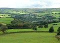
 View of the Sowerby hillside from Sowerby Bridge Footpath 93 - geograph.org.uk - 2934949.jpg 2,000 × 1,500; 1.03 MB
-
 Water chute in railway embankment - geograph.org.uk - 3966631.jpg 2,000 × 1,500; 1.88 MB
-
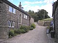
 Weavers' cottages, New Longley, Norland - geograph.org.uk - 4884109.jpg 1,496 × 2,008; 869 KB
-
 Longley - geograph.org.uk - 519967.jpg 640 × 480; 142 KB


_unofficially_diverted_-_geograph.org.uk_-_2942272.jpg)
_at_the_junction_with_Footpath_136_-_geograph.org.uk_-_2930341.jpg)


.jpg)


.jpg)


