Category:Low Catton
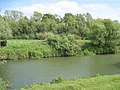
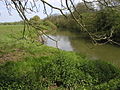
English: Low Catton is a village in the East Riding of Yorkshire, England. It is situated approximately 7 miles (11 km) north west of the market town of Pocklington and about 1 mile (1.6 km) south of the village of Stamford Bridge. It lies on the east bank of the River Derwent.
village in East Riding of Yorkshire, UK  | |||||
| Upload media | |||||
| Instance of | |||||
|---|---|---|---|---|---|
| Location | Catton, East Riding of Yorkshire, Yorkshire and the Humber, England | ||||
 | |||||
Subcategories
This category has the following 2 subcategories, out of 2 total.
G
- Gold Cup Inn, Low Catton (4 F)
L
Media in category "Low Catton"
The following 20 files are in this category, out of 20 total.
-
 Across the River Derwent to Low Catton - geograph.org.uk - 2494259.jpg 3,264 × 2,448; 2.68 MB
-
 Cuckoo Nest Farm - geograph.org.uk - 827509.jpg 640 × 411; 69 KB
-
 Footbridge - geograph.org.uk - 921278.jpg 640 × 480; 155 KB
-
 Low Catton Ings - geograph.org.uk - 921242.jpg 640 × 480; 75 KB
-
 Near Kexby - geograph.org.uk - 109049.jpg 640 × 425; 71 KB
-
 Northwest Catton - geograph.org.uk - 910935.jpg 487 × 640; 179 KB
-
 River Derwent - geograph.org.uk - 921146.jpg 640 × 480; 68 KB
-
 Road junction near the Cattons - geograph.org.uk - 109050.jpg 640 × 425; 118 KB
-
 Snow at Town End Plantation - geograph.org.uk - 722788.jpg 1,744 × 1,308; 2.27 MB
-
 The Old Rectory Low Catton.jpg 640 × 488; 115 KB
-
 The River Derwent - geograph.org.uk - 9382.jpg 640 × 480; 111 KB
-
 The River Derwent - geograph.org.uk - 9385.jpg 640 × 480; 153 KB
-
 The River Derwent Low Catton.jpg 640 × 480; 107 KB
-
 The River Derwent near Kexby - geograph.org.uk - 573750.jpg 640 × 480; 97 KB
-
 Town End Plantation - geograph.org.uk - 109054.jpg 425 × 640; 113 KB
-
 Town End Plantation Broad Lane looking towards Low Catton.jpg 1,744 × 1,308; 2.2 MB
-
 Town End Plantation Low Catton.jpg 640 × 462; 59 KB
-
 Town End Plantation.jpg 478 × 640; 226 KB
-
 Village street, Low Catton.jpg 640 × 426; 85 KB
-
 West Farm Low Catton.jpg 640 × 444; 81 KB


