Category:Low tide in the Outer Hebrides
Media in category "Low tide in the Outer Hebrides"
The following 52 files are in this category, out of 52 total.
-
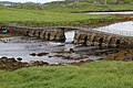
 A dry crossing^ - geograph.org.uk - 1464158.jpg 480 × 640; 97 KB
-
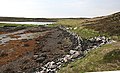
 Bay on Loch Euphort - geograph.org.uk - 1512110.jpg 640 × 480; 71 KB
-
 Boat on the beach at Bàgh a Tuath - geograph.org.uk - 1479003.jpg 640 × 480; 66 KB
-
 Brücke über einen Meeresarm auf Great Bernera, Äußere Hebriden.jpg 5,184 × 3,456; 9.47 MB
-
 Bàgh a Tuath - geograph.org.uk - 1478984.jpg 640 × 480; 54 KB
-
 Caolas Fhlodaigh - geograph.org.uk - 855812.jpg 640 × 480; 108 KB
-
 Caolas Fhlodaigh - geograph.org.uk - 855827.jpg 480 × 640; 59 KB
-
 Cnoc Mòr Thunga - geograph.org.uk - 1248881.jpg 640 × 428; 65 KB
-
 Driving over a unique beach - geograph.org.uk - 380369.jpg 640 × 428; 52 KB
-
 Eabhal from Baile Shear - geograph.org.uk - 15306.jpg 640 × 374; 50 KB
-
 Eilean an Dunain - geograph.org.uk - 842179.jpg 640 × 360; 67 KB
-
 Eilean Chairminis at low tide - geograph.org.uk - 1497105.jpg 640 × 480; 73 KB
-
 Eilean nan Uan - geograph.org.uk - 502617.jpg 640 × 359; 36 KB
-
 Faodhail a Tuath - geograph.org.uk - 1341727.jpg 640 × 383; 175 KB
-
 Faoghail Bhàlaig - geograph.org.uk - 1340930.jpg 640 × 480; 286 KB
-
 Faoghail Bhàlaig - geograph.org.uk - 1340932.jpg 480 × 640; 266 KB
-
 Inlet on Loch Langais - geograph.org.uk - 1341900.jpg 640 × 389; 227 KB
-
 Kelp beach - geograph.org.uk - 1470675.jpg 640 × 427; 109 KB
-
 Lingeigh Strand - geograph.org.uk - 840958.jpg 640 × 360; 51 KB
-
 Looking Towards Orasaigh - geograph.org.uk - 1341123.jpg 640 × 428; 273 KB
-
 Low tide at Babh Shaltabhaig - geograph.org.uk - 1522313.jpg 640 × 480; 69 KB
-
 Low tide at Rodel - geograph.org.uk - 1522432.jpg 640 × 480; 53 KB
-
 Low tide in Loch Shiaboist - geograph.org.uk - 1254645.jpg 640 × 480; 46 KB
-
 Low tide on South Uist - geograph.org.uk - 1469657.jpg 640 × 427; 51 KB
-
 Low tide, inlet and pier , Boirseam - geograph.org.uk - 1524446.jpg 640 × 480; 54 KB
-
 North East coast of Scalpay - geograph.org.uk - 146120.jpg 640 × 480; 83 KB
-
 Oronsay in Loch Nam Madadh - geograph.org.uk - 781457.jpg 640 × 480; 36 KB
-
 Rock stacks and pinnacles at Tealair - geograph.org.uk - 503469.jpg 640 × 480; 65 KB
-
 Rotting Seaweed - geograph.org.uk - 1340735.jpg 640 × 406; 252 KB
-
 Runway-operational.JPG 2,048 × 1,536; 614 KB
-
 Sandy channel between two islands. - geograph.org.uk - 505800.jpg 640 × 359; 48 KB
-
 Sewer Pipe - geograph.org.uk - 1248905.jpg 640 × 429; 106 KB
-
 Sgeir Dhreumasdail - geograph.org.uk - 1342453.jpg 640 × 260; 125 KB
-
 Sgeir Dhreumasdail - geograph.org.uk - 1512067.jpg 640 × 480; 63 KB
-
 Skigersta shore.jpg 2,592 × 1,944; 1.01 MB
-
 Traigh Bhalaigh (Vallay Beach) - geograph.org.uk - 504803.jpg 640 × 359; 45 KB
-
 Traigh Bhalaigh - geograph.org.uk - 14309.jpg 640 × 431; 39 KB
-
 Tràigh Bhalaigh - geograph.org.uk - 857742.jpg 640 × 480; 44 KB
-
 Tràigh Bhalaigh - geograph.org.uk - 857784.jpg 640 × 480; 64 KB
-
 Tràigh Bhàlaigh - geograph.org.uk - 1482387.jpg 640 × 480; 89 KB
-
 Tràigh Leathann - geograph.org.uk - 1478741.jpg 640 × 480; 70 KB
-
 Tràigh nan Sruban - geograph.org.uk - 1347853.jpg 640 × 407; 203 KB
-
 Tràigh Uige from Timsgearraidh - geograph.org.uk - 1348081.jpg 640 × 388; 178 KB
-
 Tràigh-Stir - geograph.org.uk - 1351229.jpg 640 × 385; 199 KB
-
 Tràigh-Stir - geograph.org.uk - 1351292.jpg 640 × 408; 224 KB
-
 Uig Sands, Lewis - geograph.org.uk - 152969.jpg 640 × 467; 29 KB
-
 Vallay Island from shore at low tide.jpg 437 × 221; 41 KB
-

-
 Aird Heisgeir from the beach - geograph.org.uk - 713372.jpg 480 × 640; 78 KB
-
 Beach near Cladach Chirceboist - geograph.org.uk - 1517053.jpg 640 × 622; 106 KB
-
 Bhalaigh House - geograph.org.uk - 841028.jpg 640 × 360; 29 KB
-
 Sheep beside Traigh nan Sruban - geograph.org.uk - 333220.jpg 640 × 480; 67 KB


_-_geograph.org.uk_-_504803.jpg)


