Category:Lutherkirche (Georgsmarienhütte)
| Object location | | View all coordinates using: OpenStreetMap |
|---|
church  | |||||
| Upload media | |||||
| Instance of | |||||
|---|---|---|---|---|---|
| Named after | |||||
| Location | Georgsmarienhütte, Osnabrück, Lower Saxony, Germany | ||||
| Architectural style | |||||
 | |||||
Media in category "Lutherkirche (Georgsmarienhütte)"
The following 2 files are in this category, out of 2 total.
-
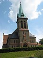 LutherkircheGeorgsmarienhuette.JPG 1,944 × 2,592; 391 KB
-
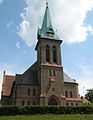 LutherkircheGeorgsmarienhuette01.jpg 1,814 × 2,349; 1.62 MB
