Category:Madagascar in the 18th century
Countries of Africa: Algeria · Angola · Benin · Cameroon · Cape Verde · Chad · Comoros · Republic of the Congo · Djibouti · Egypt‡ · Equatorial Guinea · Eritrea · Ethiopia · The Gambia · Ghana · Guinea · Guinea-Bissau · Ivory Coast · Libya · Madagascar · Mali · Mauritania · Mauritius · Morocco · Mozambique · São Tomé and Príncipe · Senegal · Sierra Leone · Somalia · South Africa · Sudan · Tanzania · Tunisia
Other areas: Canary Islands · Ceuta · Madeira · Mayotte · Melilla · Réunion
‡: partly located in Africa
Other areas: Canary Islands · Ceuta · Madeira · Mayotte · Melilla · Réunion
‡: partly located in Africa

Subcategories
This category has only the following subcategory.
*
- 18th-century maps of Madagascar (44 F)
Media in category "Madagascar in the 18th century"
The following 6 files are in this category, out of 6 total.
-

-

-

-

-
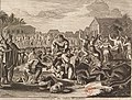 Circoncision à Madagascar, estampe tirée de La galerie agréable du monde.jpg 2,593 × 1,977; 4.31 MB
-

m_Nichelson..._;_Spilsbury..._sculp(sit)_-_btv1b531426800_(2_of_6).jpg)
m_Nichelson..._;_Spilsbury..._sculp(sit)_-_btv1b531426800_(3_of_6).jpg)
m_Nichelson..._;_Spilsbury..._sculp(sit)_-_btv1b531426800_(4_of_6).jpg)
m_Nichelson..._;_Spilsbury..._sculp(sit)_-_btv1b531426800_(5_of_6).jpg)
