Category:Maesycoed
village in United Kingdom  | |||||
| Upload media | |||||
| Instance of | |||||
|---|---|---|---|---|---|
| Location | Rhondda Cynon Taf, Wales | ||||
 | |||||
English: Maesycoed is a settlement to the south and west of Pontypridd town centre in the county borough of Rhondda Cynon Taf, Wales. Maesycoed is a district in the town of Pontypridd within the Rhondda electoral ward and is bounded by Graig to the south, Pwllgwaun to the east and Hopkinstown and Mynydd Gelliwion to the north.
Media in category "Maesycoed"
The following 19 files are in this category, out of 19 total.
-
 Allotments, Gelliwion Rd, Maesycoed, Pontypridd - geograph.org.uk - 5584783.jpg 4,608 × 3,456; 3.89 MB
-
 Cattle grid, Gelliwion Rd, near Pontypridd - geograph.org.uk - 5584798.jpg 4,608 × 3,456; 3.88 MB
-
 Coed-Isaf Road, Maesycoed. - geograph.org.uk - 1655619.jpg 640 × 480; 63 KB
-

-
 Former church, Golgafar Eglwys, Pontypridd - geograph.org.uk - 5584761.jpg 4,608 × 3,456; 3.59 MB
-

-
 Gelliwion Rd, Gelli-wion - geograph.org.uk - 5584833.jpg 4,608 × 3,456; 3.85 MB
-
 Gelliwion Rd, Maesycoed, Pontypridd - geograph.org.uk - 5584787.jpg 4,608 × 3,456; 3.78 MB
-
 Hermon Presbyterian Church, Maesycoed, Pontypridd - geograph.org.uk - 5584750.jpg 4,608 × 3,456; 3.66 MB
-
 Houses in Lanelay Terrace, Maesycoed, Pontypridd - geograph.org.uk - 5584770.jpg 4,608 × 3,456; 3.74 MB
-
 Maesycoed Primary School, Pontypridd - geograph.org.uk - 5584774.jpg 4,608 × 3,456; 3.73 MB
-
 Ordnance Survey Cut Mark - geograph.org.uk - 5817492.jpg 1,024 × 929; 349 KB
-
 Ordnance Survey Cut Mark - geograph.org.uk - 5817493.jpg 1,024 × 850; 298 KB
-
 Ordnance Survey Cut Mark - geograph.org.uk - 5817507.jpg 1,024 × 762; 267 KB
-
 Ordnance Survey Cut Mark - geograph.org.uk - 5817508.jpg 1,024 × 720; 254 KB
-
 Ordnance Survey Rivet - geograph.org.uk - 5817491.jpg 810 × 1,024; 396 KB
-
-
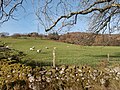
 Sheep grazing, Gelli-wion - geograph.org.uk - 5584811.jpg 4,608 × 3,456; 3.74 MB
-
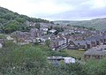 Maesycoed - geograph.org.uk - 413468.jpg 640 × 456; 73 KB


