Category:Magharee Islands
group of 7 islands in County Kerry, Island  | |||||
| Upload media | |||||
| Instance of |
| ||||
|---|---|---|---|---|---|
| Location |
| ||||
| Located in or next to body of water | |||||
 | |||||
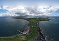
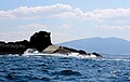
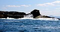
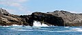
The Magharee Islands (Irish: Na Machairí), also known as "The Seven Hogs", are a group of uninhabited islands located off Rough Point at the northern tip of the Magharee Peninsula in County Kerry, Ireland.
Media in category "Magharee Islands"
The following 46 files are in this category, out of 46 total.
-
 2019-07-26-Magharee Islands-0754.jpg 5,463 × 3,073; 11.15 MB
-
 2019-07-26-Magharee Peninsula-0757 (cropped).jpg 4,116 × 2,907; 7.79 MB
-
 2019-07-26-Magharee Peninsula-0757.jpg 8,192 × 4,096; 15.02 MB
-
 2019-07-26-seven hogs-0762.jpg 5,464 × 3,640; 14.99 MB
-
 Algae-8794, Dingle Peninsula, Co. Kerry, Ireland.jpg 1,920 × 1,080; 479 KB
-
 Brandon Bay-4416, Dingle Peninsula, Co. Kerry, Ireland.jpg 1,920 × 1,080; 241 KB
-
 Brandon Point-4874, Dingle Peninsula, Co. Kerry, Ireland.jpg 1,920 × 1,080; 577 KB
-
 High Tide-0497, Dingle Peninsula, Co. Kerry, Ireland.jpg 1,920 × 1,080; 525 KB
-
 Hiker-4869, Dingle Peninsula, Co. Kerry, Ireland.jpg 1,920 × 1,080; 513 KB
-
 Illaunimmil - geograph.org.uk - 500452.jpg 640 × 480; 57 KB
-
 Island-8828, The Maharees, Dingle Peninsula, Co. Kerry, Ireland.jpg 1,920 × 1,080; 264 KB
-
 Kerry Head-4881, Tralee Bay, Co. Kerry, Ireland.jpg 1,920 × 1,080; 230 KB
-
 Look-out-4438, Dingle Peninsula, Co. Kerry, Ireland.jpg 1,920 × 1,080; 351 KB
-
 Magharees (33592974804).jpg 2,254 × 1,029; 580 KB
-
 Magharees (33593127104).jpg 2,067 × 1,112; 433 KB
-
 Magharees (33593163014).jpg 1,627 × 1,035; 322 KB
-
 Magharees (33593163644).jpg 2,191 × 933; 282 KB
-
 Magharees (33625143483).jpg 2,256 × 1,146; 351 KB
-
 Magharees (33625691853).jpg 2,195 × 1,000; 306 KB
-
 Magharees (34050325420).jpg 1,996 × 1,088; 482 KB
-
 Magharees (34050326120).jpg 1,984 × 802; 267 KB
-
 Magharees (34275595252).jpg 1,918 × 1,059; 350 KB
-
 Magharees (34276264142).jpg 2,255 × 1,107; 366 KB
-
 Magharees (34304368691).jpg 1,904 × 883; 313 KB
-
 Magharees (34393690466).jpg 2,256 × 950; 343 KB
-
 Magharees (34394285506).jpg 2,246 × 1,053; 374 KB
-
 Magharees (34435028725).jpg 1,017 × 429; 138 KB
-
 Magharees - look twice (34393490156).jpg 1,998 × 881; 313 KB
-
 Magharees.jpg 2,048 × 1,536; 991 KB
-
 Maharees-2991, Tralee Bay, Co. Kerry, Ireland.jpg 5,184 × 3,888; 3.57 MB
-
 Maharees-2997, Tralee Bay, Co. Kerry, Ireland.jpg 5,184 × 3,888; 3.26 MB
-
 Sheep-4858, Dingle Peninsula, Co. Kerry, Ireland.jpg 1,920 × 1,080; 316 KB
-
 Sign-4787, Dingle Peninsula, Co. Kerry, Ireland.jpg 1,920 × 1,080; 791 KB
-
 Sign-4898, Dingle Peninsula, Co. Kerry, Ireland.jpg 1,920 × 1,080; 300 KB
-
 Sign-5112, Dingle Peninsula, Co. Kerry, Ireland.jpg 1,920 × 1,080; 625 KB
-
 Sign-8764, Tralee Bay, Co. Kerry, Ireland.jpg 1,920 × 1,080; 387 KB
-
 Sign-8813, Dingle Peninsula, Co. Kerry, Ireland.jpg 1,920 × 1,080; 816 KB
-
 Stile-4785, Dingle Peninsula, Co. Kerry, Ireland.jpg 1,920 × 1,080; 647 KB
-
 Stone Wall-4911, Dingle Peninsula, Co. Kerry, Ireland.jpg 1,920 × 1,080; 344 KB
-
 Symbol-4376, Dingle Peninsula, Co. Kerry, Ireland.jpg 5,184 × 3,888; 3.27 MB
-
 Symbol-4894, Dingle Peninsula, Co. Kerry, Ireland.jpg 1,920 × 1,080; 251 KB
-
 Tralee Bay (34874713780).jpg 991 × 405; 87 KB
-
 Tralee Bay (35095832772).jpg 2,065 × 702; 227 KB
-
 Walker-5103, Dingle Peninsula, Co. Kerry, Ireland.jpg 1,920 × 1,080; 293 KB
-
 Waves - geograph.org.uk - 219597.jpg 600 × 450; 48 KB
-
 Gurrig Island - geograph.org.uk - 500462.jpg 640 × 480; 48 KB

.jpg)


.jpg)
.jpg)
.jpg)
.jpg)
.jpg)
.jpg)
.jpg)
.jpg)
.jpg)
.jpg)
.jpg)
.jpg)
.jpg)
.jpg)


.jpg)
.jpg)
.jpg)