Category:Maitenbeth
municipality of Germany    | |||||
| Upload media | |||||
| Pronunciation audio | |||||
|---|---|---|---|---|---|
| Instance of |
| ||||
| Part of |
| ||||
| Location | Mühldorf, Upper Bavaria, Bavaria, Germany | ||||
| Head of government |
| ||||
| Population |
| ||||
| Area |
| ||||
| Elevation above sea level |
| ||||
| official website | |||||
 | |||||
Subcategories
This category has the following 2 subcategories, out of 2 total.
B
C
Media in category "Maitenbeth"
The following 11 files are in this category, out of 11 total.
-
 DEU Maitenbeth COA.svg 979 × 1,056; 86 KB
-
 Wappen Maitenbeth.png 212 × 227; 7 KB
-
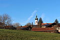
 Brandstätt, Wieskapelle (1.1).jpg 3,056 × 3,056; 2.89 MB
-
 Brandstätt, Wieskapelle, Gde. Maitenbeth, 7. März 2024 (1b).jpg 2,448 × 2,448; 1.62 MB
-
 Geotop Toteiskessel (Maitenbeth).jpg 6,000 × 4,000; 13.08 MB
-
 Luhestätt, Einöde d. Gde. Maitenbeth (1).jpg 2,448 × 3,264; 1.41 MB
-
 Maitenbeth in MÜ.svg 604 × 535; 1.2 MB
-
 Maitenbeth.jpeg 5,184 × 3,456; 7.26 MB
-
 Naturdenkmal Winterlinde (Maitenbeth).jpg 4,000 × 6,000; 12.86 MB
-
 Ortskern Maitenbeth.jpg 6,000 × 1,413; 2.69 MB
-
 Skulpturenpark in Maitenbeth - geo.hlipp.de - 13935.jpg 640 × 480; 77 KB

.jpg)
.jpg)
.jpg)
.jpg)

.jpg)
