Category:Malom-tó (Albertirsa)
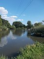
English: : ~Mill Lake (Fishing/angling lake, Fish lake). Using by Malom-tó Angling Association. According local note the lake was created by the Gerje Stream damming in the 15th century for a local citizen named Mrs. Margaret who in 1411 built a water mill and got fishing . In middle of the lake is an artificial island (the result of dredging). The coastal areas and the island are covered with grass. The average water depth of the lake is 1.5 meters, but in some places there are also water depths approaching 2.5 meters. The lake is a circa 4-hectare, elliptical reservoir at the Tó Street Albertirsa, Pest County, Hungary
Magyar: : Malom-tó (Horgásztó, Halastó). A Monor-Irsai dombság illetve a Duna-Tisza közi Homokhátság és síkvidéki részek határán húzódik a Gerje-patak völgye. A Gerje-patak mentén, annak felduzzasztásával jött létre az Albertirsa északi szélén elhelyezkedő, kb. négy hektár nagyságú, ellipszis formájú víztározó. A part menti területek és maga a sziget fűvel borított. A horgásztavat, a Malom-tó Horgászegyesület tagjai egész évben használhatják. Source: sulinet.hu és albertirsa.hu - Pest megye, Albertirsa, Tó utca végén.
| Object location | | View all coordinates using: OpenStreetMap |
|---|
Media in category "Malom-tó (Albertirsa)"
The following 12 files are in this category, out of 12 total.
-
 Lake, E, 2020 Albertirsa.jpg 2,272 × 1,704; 1 MB
-
 Lake, from S to N, 2020 Albertirsa.jpg 2,272 × 1,704; 1,023 KB
-
 Lake, N, 2020 Albertirsa.jpg 2,272 × 1,704; 999 KB
-
 Lake, overhead power line crossing, 2020 Albertirsa.jpg 1,704 × 2,272; 1.11 MB
-
 Lake, overhead power line crossing, S, 2020 Albertirsa.jpg 2,272 × 1,704; 1,002 KB
-
 Lake, S, 2020 Albertirsa.jpg 2,272 × 1,704; 1.03 MB
-
 Lake, SE, 2020 Albertirsa.jpg 2,272 × 1,704; 985 KB
-
 Lake, SE, water gauge, 2020 Albertirsa.jpg 1,603 × 2,139; 928 KB
-
 Lake, sluice, 2020 Albertirsa.jpg 1,645 × 2,193; 1.13 MB
-
 Lake, W, boats, 2020 Albertirsa.jpg 1,704 × 2,272; 1.52 MB
-
 Lake, west coast, N, 2020 Albertirsa.jpg 2,272 × 1,704; 1,016 KB
-
 See, W, Boote, 2020 Albertirsa.jpg 2,272 × 1,704; 978 KB


