Category:Manchester, Bolton and Bury Canal, Kearsley
Media in category "Manchester, Bolton and Bury Canal, Kearsley"
The following 52 files are in this category, out of 52 total.
-
 Appleyard Bridge - geograph.org.uk - 2163876.jpg 800 × 600; 355 KB
-
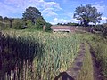
 Bulrushes at the canal side - geograph.org.uk - 4358306.jpg 4,592 × 3,056; 7.37 MB
-
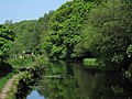
 Canal at Prestolee - geograph.org.uk - 4212580.jpg 2,500 × 1,797; 4.75 MB
-
 Canal crossing underneath fold road at ringley village.jpg 1,496 × 1,988; 581 KB
-
 Canal passing red rock lane.jpg 2,083 × 1,120; 350 KB
-
 Dickies bridge manchester bolton bury canal.jpg 640 × 408; 136 KB
-
 Footpath at Ringley - geograph.org.uk - 2969155.jpg 640 × 480; 623 KB
-
 Kearsley - canal towpath above River Irwell - geograph.org.uk - 2957570.jpg 1,600 × 1,200; 923 KB
-
 Kearsley - canal west of Ringley Bridge - geograph.org.uk - 2957558.jpg 1,600 × 1,200; 792 KB
-
 Kearsley road where canal crosses under.jpg 2,118 × 1,118; 289 KB
-
 Manchester Bolton and Bury canal Red Rock Lane.jpg 2,048 × 1,536; 956 KB
-
 Manchester Bolton and Bury canal Ringley Top Lock.jpg 1,536 × 2,048; 1,024 KB
-
 Manchester bolton and bury canal ringley village looking north of folds road.jpg 2,409 × 1,425; 593 KB
-
 Manchester Bolton and Bury canal Stoneclough.jpg 2,048 × 1,536; 892 KB
-
 Manchester Bolton ^ Bury Canal - Salford arm - geograph.org.uk - 4678903.jpg 1,600 × 900; 478 KB
-
 Manchester Bolton ^ Bury Canal near Kearsley - geograph.org.uk - 4390644.jpg 1,600 × 1,200; 797 KB
-
 Manchester Bolton ^ Bury Canal pathway - geograph.org.uk - 4343245.jpg 1,600 × 900; 495 KB
-

-

-

-

-

-

-

-

-

-

-
 Manchester, Bolton ^ Bury Canal - geograph.org.uk - 2163553.jpg 800 × 600; 335 KB
-
 Manchester, Bolton ^ Bury Canal - geograph.org.uk - 2163725.jpg 800 × 600; 288 KB
-
 Manchester, Bolton ^ Bury Canal - geograph.org.uk - 2163767.jpg 800 × 600; 312 KB
-
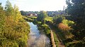
 Manchester, Bolton ^ Bury Canal above Prestolee - geograph.org.uk - 6014805.jpg 5,184 × 2,920; 7.41 MB
-
 Manchester, Bolton ^ Bury Canal towpath N of Prestolee - geograph.org.uk - 6014815.jpg 5,184 × 2,920; 7.15 MB
-

-

-
-

-

-

-
 Manchester, Bolton ^ Bury Canal, Prestolee Aqueduct - geograph.org.uk - 2711997.jpg 1,280 × 960; 1.34 MB
-
 Mbb canal past prestolee aqueduct.jpg 2,048 × 1,536; 730 KB
-
 Mbb canal ringley village heading to giants seat lock.jpg 2,899 × 1,041; 611 KB
-
 MBB Canal-bridge.jpg 350 × 255; 16 KB
-

-
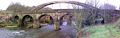 Pack horse bridge stoneclough.jpg 3,040 × 960; 530 KB
-
 Prestolee Aqueduct - geograph.org.uk - 2163717.jpg 800 × 600; 341 KB
-
 Prestolee Aqueduct - geograph.org.uk - 2937368.jpg 640 × 481; 560 KB
-

-
 Site of Ringley Upper Lock Manchester Bolton and Bury Canal.jpg 640 × 414; 127 KB
-
 The Bolton Canal - geograph.org.uk - 4356245.jpg 4,592 × 3,056; 7.69 MB
-
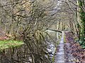
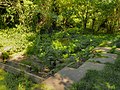
 The Bolton canal is somewhat overgrown - geograph.org.uk - 4356210.jpg 4,592 × 3,056; 7.4 MB
-
 The canal near Prestolee Bridge - geograph.org.uk - 4414597.jpg 1,024 × 768; 210 KB
-
 The End of the Canal at Ringley - geograph.org.uk - 2969142.jpg 640 × 480; 641 KB


_Locks_-_geograph.org.uk_-_3313222.jpg)


.jpg)


,_Manchester,Bolton_and_Bury_Canal_-_geograph.org.uk_-_2937357.jpg)


