<nowiki>Manteler Forst; Manteler Forst; Manteler Forst; Manteler Forst; Manteler Forst; Manteler Forst; Manteler Forst; Manteler Forst; Manteler Forst; Manteler Forst; Manteler Forst; Manteler Forst; Manteler Forst; Manteler Forst; Manteler Forst; Manteler Forst; Manteler Forst; Manteler Forst; Manteler Forst; Manteler Forst; Manteler Forst; Manteler Forst; Manteler Forst; Manteler Forst; Manteler Forst; Manteler Forst; Manteler Forst; Manteler Forst; Manteler Forst; Manteler Forst; Manteler Forst; Manteler Forst; Manteler Forst; Manteler Forst; Manteler Forst; Manteler Forst; Manteler Forst; Manteler Forst; Manteler Forst; Manteler Forst; Manteler Forst; Manteler Forst; Manteler Forst; Manteler Forst; Manteler Forst; Manteler Forst; Manteler Forst; Manteler Forst; Manteler Forst; Manteler Forst; Manteler Forst; Manteler Forst; Manteler Forst; Manteler Forst; Manteler Forst; Manteler Forst; Manteler Forst; Manteler Forst; Manteler Forst; Manteler Forst; Manteler Forst; Manteler Forst; Manteler Forst; Manteler Forst; Manteler Forst; Manteler Forst; Manteler Forst; Manteler Forst; Manteler Forst; Manteler Forst; Manteler Forst; Manteler Forst; Manteler Forst; Gemeindefreies Gebiet im Landkreis Neustadt an der Waldnaab in Bayern; unincorporated area in Germany</nowiki>
Subcategories
This category has only the following subcategory.


 2023 Manteler Forst 01.jpg 6,720 × 4,480; 20.25 MB
 Digitales Orthofoto von Manteler Forst (Bayerische Vermessungsverwaltung).tif 22,500 × 22,500; 944.36 MB
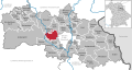 Manteler Forst in NEW.svg 1,000 × 532; 740 KB