Category:Maps by John Hills
Media in category "Maps by John Hills"
The following 54 files are in this category, out of 54 total.
-

-

-

-

-
 A map of Monmouth County. LOC gm72003604.jpg 16,217 × 9,048; 14.52 MB
-
 A map of Monmouth County. LOC gm72003604.tif 16,217 × 9,048; 419.8 MB
-
 A map of part of the province of Jersey. LOC gm72003589.jpg 8,264 × 6,151; 6.3 MB
-
 A map of part of the province of Jersey. LOC gm72003589.tif 8,264 × 6,151; 145.43 MB
-
 A map, Middlesex County. LOC gm72003603.jpg 8,665 × 7,694; 6.65 MB
-
 A map, Middlesex County. LOC gm72003603.tif 8,665 × 7,694; 190.74 MB
-
 A map, Somerset County. LOC gm72003602.jpg 8,172 × 5,829; 5.48 MB
-
 A map, Somerset County. LOC gm72003602.tif 8,172 × 5,829; 136.28 MB
-

-

-

-
 A sketch of the northern parts of New Jersey. LOC gm72003605.jpg 10,324 × 11,900; 16.35 MB
-
 A sketch of the northern parts of New Jersey. LOC gm72003605.tif 10,324 × 11,900; 351.49 MB
-
 Boston Harbour, with the surroundings, etc. LOC gm71000625.jpg 16,124 × 9,011; 16.18 MB
-
 Boston Harbour, with the surroundings, etc. LOC gm71000625.tif 16,124 × 9,011; 415.69 MB
-
 HillsMap1796.jpg 2,800 × 2,042; 806 KB
-
 Plan of Paulus Hook shewing the works erected for its defence, 1781-2 LOC gm72003609.jpg 5,999 × 7,769; 3.96 MB
-
 Plan of Paulus Hook shewing the works erected for its defence, 1781-2 LOC gm72003609.tif 5,999 × 7,769; 133.34 MB
-

-

-

-

-
 Plan of the lots laid out at Pittsburg and the Coal Hill. LOC 74692580.jpg 10,377 × 5,590; 8.2 MB
-
 Plan of the lots laid out at Pittsburg and the Coal Hill. LOC 74692580.tif 10,377 × 5,590; 165.96 MB
-

-

-

-

-

-
 Sketch of Brunswick. Sketch of the ground near Mr. Low's at Rariton Landing. LOC gm72003593.tif 3,323 × 5,808; 55.22 MB
-
-

-

-

-

-

-

-

-
 Sketch of the ground near Mr. Low's at Rariton Landing. LOC gm72003593 (cropped).jpg 3,134 × 2,551; 913 KB
-

-
 Sketch of the road from Black Horse to Crosswick, LOC gm72003597.jpg 6,586 × 5,824; 3.98 MB
-
 Sketch of the road from Black Horse to Crosswick, LOC gm72003597.tif 6,586 × 5,824; 109.74 MB
-
 Sketch of the road from Black Horse to Crosswick. Sketch of Allen's Town. LOC gm71002190.jpg 7,896 × 5,838; 4.89 MB
-
 Sketch of the road from Black Horse to Crosswick. Sketch of Allen's Town. LOC gm71002190.tif 7,896 × 5,838; 131.88 MB
-
 Sketch of the road from Paulus Hook and Hobocken to New Bridge. LOC gm72003607.tif 7,232 × 8,707; 180.16 MB
-

-

-

-
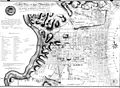
 This plan of the city of Philadelphia and its environs (showing the improved parts) LOC 2007625050.tif 11,428 × 8,159; 266.77 MB
-


_stormed_by_His_Majesty%27s_forces_under_the_command_of_Sr._Henry_Clinton,_KB,_the_6th_of_October_1777._LOC_gm71000667.jpg)


.jpg)
.jpg)


_LOC_2007625050.jpg)
.jpg)