Category:Maps by Rand McNally
Subcategories
This category has the following 2 subcategories, out of 2 total.
Media in category "Maps by Rand McNally"
The following 136 files are in this category, out of 136 total.
-
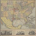 Rand, McNally and Co. Map of the Houston and Texas Central Railway 1880 UTA.jpg 8,476 × 8,528; 11.04 MB
-
 1886 Chicago map by Rand McNally.jpg 3,602 × 4,539; 4.98 MB
-
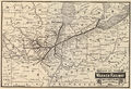 1887 Wabash map only.jpg 2,803 × 1,924; 1.51 MB
-
 Rand, McNally & Co. Map of Texas 1889 UTA.jpg 3,004 × 2,688; 1.6 MB
-
 1889 China Map by Rand McNally and Company.jpg 1,077 × 1,536; 612 KB
-
 1890 Chicago map by Rand McNally.jpg 7,084 × 8,938; 17.65 MB
-
 1892 Lima detail map Bolivia, Ecuador and Peru by Rand McNally BPL 10012.png 1,064 × 746; 1.66 MB
-
 WHEELER1893 pg020 MAP YELLOSTONE PARK REGION.jpg 1,833 × 2,490; 3.43 MB
-
 1893 Rand McNally Standard Map of Chicago.jpg 12,282 × 20,292; 48.55 MB
-
 (1898) MAP OF CUBA.jpg 4,717 × 2,915; 8.96 MB
-
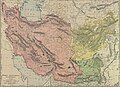 1898 crop of Persia, Afghanistan and Baluchistan. LOC 2004629231.jpg 7,831 × 5,709; 8.12 MB
-
 1903 Rand McNally Chicago Map.jpg 7,770 × 11,742; 25.03 MB
-
 1912 Chicago map by Rand McNally - North.jpg 8,500 × 9,756; 14.56 MB
-
 1912 Chicago map by Rand McNally - South.jpg 7,500 × 8,563; 11.95 MB
-
 1913 Chicago Map by Rand McNally.jpg 9,646 × 16,220; 62.29 MB
-
 1919-07-00SP-USRA BayFerry-ElecTrns.jpg 3,385 × 2,310; 1.78 MB
-
 Rand McNally Standard Map of Texas 1921 UTA.jpg 2,688 × 3,681; 1.69 MB
-
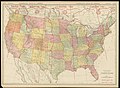 Rand McNally Standard Map of the United States 1921 UTA.jpg 3,673 × 2,688; 1.93 MB
-
 1921 Railway terminal map of Chicago by Rand McNally.jpg 2,800 × 3,765; 8.15 MB
-
 1922 New England road map 2.jpg 1,311 × 839; 387 KB
-
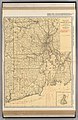 1924 Rand McNally Standard Map of Rhode Island.jpg 7,978 × 12,249; 13.49 MB
-

-

-
 Americana 1920 Cincinnati.jpg 2,994 × 4,032; 4.95 MB
-
 Arizona1895.jpg 1,700 × 2,478; 839 KB
-
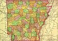 Arkansas1895.jpg 2,390 × 1,692; 784 KB
-
 Asia 1914-1938-1950.jpg 1,140 × 1,485; 616 KB
-
 Atlantic Ocean 1953.jpg 1,008 × 1,391; 527 KB
-
 Austria-Hungary WDL40.png 1,362 × 1,024; 2.94 MB
-
 Carte de l'Autriche-Hongrie.jpg 1,362 × 1,024; 2.58 MB
-
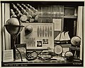
 Cartographic Publishing - Displays (NBY 5534).jpg 3,600 × 2,475; 885 KB
-
 Cartographic Publishing Production Procedures (NBY 4928).jpg 3,600 × 2,897; 1.28 MB
-

-
 ChattanoogaTN1925RandMcNally.png 2,100 × 1,847; 1,007 KB
-

-
 China, Indo-China, Malaysia.jpg 5,282 × 6,994; 19.94 MB
-
 Cleveland - NARA - 26335550.jpg 8,448 × 6,164; 8.31 MB
-
 Colombia and Venezuela WDL71.png 1,356 × 1,024; 2.63 MB
-
 Cosmo Series world map, 1962.jpg 5,329 × 3,443; 6.43 MB
-

-
 EthiopiaRAND1908.jpg 348 × 472; 60 KB
-
 Eurasia, 1953.jpg 1,621 × 1,276; 951 KB
-
 Europe 1914-1938-1950.jpg 1,140 × 1,460; 524 KB
-
 Hawaii (1899).jpg 4,506 × 3,021; 11.93 MB
-

-

-

-
 Land and water hemispheres, 1906.jpg 1,516 × 835; 492 KB
-
 Map of 1893 World's Columbian Exposition by Rand McNally.jpg 8,111 × 5,415; 9.58 MB
-
 Map of Cuba (1899).jpg 4,403 × 3,020; 10.81 MB
-
 Map of Europe, 1959.jpg 2,738 × 1,928; 2.17 MB
-
 Map of Franklin County, Ohio LOC 2012592222.jpg 16,029 × 11,916; 35.21 MB
-
 Map of Germany 1892 (Rand McNally and Company).jpg 7,762 × 6,114; 9.52 MB
-
 Map of Persia, Afghanistan and Baluchistan - 1898.tif 2,715 × 1,024; 7.95 MB
-
 Map of the Eastern Hemisphere.jpg 2,659 × 2,623; 1.66 MB
-
 Map of the island of Porto Rico. LOC 00552205.jpg 19,680 × 10,592; 45.49 MB
-
 Map of the island of Porto Rico. LOC 00552205.tif 19,680 × 10,592; 596.38 MB
-
 Map of the Western Hemisphere.jpg 2,624 × 2,577; 1.34 MB
-
 Map-of-Puerto-Rico-(1898).jpg 4,489 × 2,801; 5.61 MB
-
 Map-of-Puerto-Rico-1898.jpg 3,840 × 3,099; 6.36 MB
-
 Middle East, SW Asia and NE Africa c1955 (7980165629).jpg 948 × 1,232; 330 KB
-

-
 New railroad and township map of Arkansas - btv1b530581573.jpg 6,154 × 4,449; 5.28 MB
-
 New railroad, county and township map of Colorado - DPLA - d6ac14895275bb226ce1df2d274b4dff.jpg 9,000 × 7,139; 12.21 MB
-
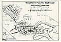
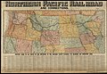 Northern Pacific Rail Road and connections (14533461260).jpg 2,000 × 1,376; 3.26 MB
-
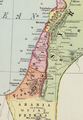
 Palestine, or, the Holy Land ; Persia, Afghanistan and Beluchistan. LOC 2006627700.tif 6,110 × 8,335; 145.7 MB
-
 Persia, Afghanistan and Baluchistan WDL12985.png 1,319 × 1,024; 3.44 MB
-
 Persia, Afghanistan and Baluchistan WDL2678.png 2,715 × 1,024; 5.55 MB
-
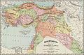
 Persia, Afghanistan and Baluchistan. LOC 2004629231.jpg 17,266 × 6,510; 18.5 MB
-
 Persia, Afghanistan and Baluchistan. LOC 2004629231.tif 17,266 × 6,510; 321.58 MB
-
 Persia, Afghanistan and Beluchistan. LOC 2006626070.jpg 4,164 × 3,231; 4.6 MB
-
 Persia, Afghanistan and Beluchistan. LOC 2006626070.tif 4,164 × 3,231; 38.49 MB
-
 Persia, Afghanistan and Beluchistan. LOC 2006626071.jpg 4,217 × 3,369; 3.44 MB
-
 Philippine Islands (1898).jpg 2,886 × 4,449; 10.38 MB
-
 Polar map of the world, 1943.jpg 1,674 × 2,225; 1.09 MB
-
 Polar World map 1945.jpg 1,401 × 1,673; 1.19 MB
-
 Political map of Europe, 1931.jpg 6,504 × 8,999; 6.06 MB
-
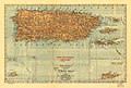
 Puerto Rico 1915 Rand McNally map.jpg 4,920 × 2,648; 3.36 MB
-
 Railroad map of New Mexico in 1904.jpg 1,342 × 2,000; 3.25 MB
-

-
 Rand McNally 14 x 21 inch map of Porto Rico. LOC 98687142.jpg 6,119 × 4,129; 5.22 MB
-
 Rand McNally 14 x 21 inch map of Porto Rico. LOC 98687142.tif 6,119 × 4,129; 72.29 MB
-

-
 Rand McNally Atlas window display (NBY 4833).jpg 3,600 × 2,910; 1.35 MB
-
 Rand McNally Historical Flight Map, 1928.jpg 5,030 × 3,487; 5.34 MB
-

-

-
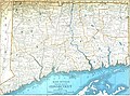 Rand McNally Map of Connecticut.jpg 3,580 × 2,667; 2.82 MB
-
 Rand McNally Map of Maryland.jpg 3,575 × 2,663; 3.37 MB
-
 Rand McNally Map of New Jersey.jpg 2,629 × 3,591; 2.66 MB
-
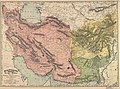 Rand McNally map of Persia,Afghanistan,Baluchistan.jpg 1,995 × 1,487; 967 KB
-
 Rand McNally Map of Rhode Island.jpg 2,668 × 3,648; 2.67 MB
-

-
 Rand McNally official 1920 auto trails map, New York City and vicinity. LOC 88695915.jpg 5,980 × 7,673; 7.52 MB
-
 Rand McNally Queens - from Rand McNally metropolitan map of New York City. LOC 2005625364.tif 11,965 × 9,677; 331.26 MB
-
 Rand McNally standard map of Tennessee (Full Size).jpg 16,400 × 6,000; 15.28 MB
-
 Rand McNally standard map of Washington D.C. LOC 87691489.jpg 8,064 × 6,161; 8.58 MB
-
 Rand McNally standard map of Washington D.C. LOC 87691489.tif 8,064 × 6,161; 142.14 MB
-
 Rand, Mac Nally & Co's Connecticut - btv1b530584164.jpg 4,388 × 3,414; 2.59 MB
-
 Rand, Mac Nally & Co's Georgia - btv1b53057731h.jpg 4,417 × 6,390; 5.26 MB
-
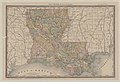 Rand, Mac Nally & Co's Louisiana - btv1b530576816.jpg 6,404 × 4,396; 5.37 MB
-
 Rand, Mac Nally & Co's Manitoba - btv1b53058145s.jpg 6,456 × 4,466; 4.84 MB
-
 Rand, Mac Nally & Co's South. (and North) Caroline - btv1b53058845f.jpg 6,391 × 4,371; 5.66 MB
-
 Rand, Mac Nally & Co's. New Hampshire - btv1b53058677t.jpg 4,224 × 6,472; 5.22 MB
-
 Rand, Mac Nally & Co. 's Florida - btv1b530579659.jpg 4,420 × 6,337; 4.88 MB
-
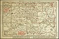
 Rand, Mac Nally and Co's Colorado - btv1b530578688.jpg 6,233 × 4,354; 5.53 MB
-
 Rand, Mac Nally and Co's Utah - btv1b530575254.jpg 4,443 × 6,369; 4.75 MB
-
 Rand, Mac Nally and Co's Wyoming - btv1b530591024.jpg 7,393 × 5,619; 7.91 MB
-
 Rand, Mc Nally and Co's Colorado - btv1b53057892t.jpg 8,216 × 6,432; 10.61 MB
-

-
 Rand, McNally & Co.'s indexed atlas of the world - map of Washington, D.C. LOC 88693365.jpg 8,051 × 6,086; 8.97 MB
-
 Rand, McNally & Co.'s indexed atlas of the world - map of Washington, D.C. LOC 88693365.tif 8,051 × 6,086; 140.19 MB
-
 Rand, McNally & Co.'s indexed atlas of the world - map of Washington, D.C. LOC 88693366.jpg 8,694 × 6,306; 8.75 MB
-

-
 Rand, McNally & Co.'s Kentucky. LOC 79691679.jpg 8,553 × 6,342; 10.56 MB
-
 Rand, McNally & Co.'s map of Idaho (NBY 15524).jpg 3,600 × 2,422; 1.97 MB
-
 Rand, McNally & Co.'s map of Oklahoma and Indian Territories (NBY 15598).jpg 3,600 × 2,396; 2.07 MB
-
 Rand, McNally & Co.'s map of the main portion of Washington, D.C. LOC 88693359.jpg 3,034 × 4,074; 2.2 MB
-
 Rand, McNally & Co.'s map of the main portion of Washington, D.C. LOC 88693359.tif 3,034 × 4,074; 35.36 MB
-
-
-

-

-
-
 Reference map of the Pacific Ocean, 1944.jpg 2,749 × 1,943; 2.12 MB
-
 South India 1899 Rand McNally.jpg 3,184 × 2,370; 7.91 MB
-
 Territorial Acquisitions of the United States.jpg 3,506 × 2,752; 3.1 MB
-

-

-
 The Rand McNally new commercial atlas map of South Carolina (14004922492).jpg 2,000 × 1,496; 3.36 MB
-
 The Rand-McNally new library atlas map of Europe LOC 2007627462.jpg 8,490 × 6,244; 8.84 MB
-

-
 War map Atlantic, Eurasia, Africa, Pacific Ocean.jpg 3,110 × 4,136; 2.82 MB
-
 West Africa 1940s (7819230290).jpg 1,103 × 1,452; 491 KB
-
 World affairs map, 1959.jpg 3,066 × 2,249; 2.32 MB
-
 World on Mercator projection, 1904.jpg 1,562 × 1,304; 805 KB


_MAP_OF_CUBA.jpg)


.jpg)
.jpg)


.jpg)
.jpg)
.jpg)

.jpg)


_(cropped).jpg)


.jpg)


.jpg)


.jpg)


.jpg)

.jpg)


.jpg)


.jpg)


.jpg)

.jpg)
.jpg)

_of_the_United_States._LOC_98687208.jpg)


.jpg)


_Caroline_-_btv1b53058845f.jpg)


.jpg)

.jpg)
.jpg)

.jpg)

.jpg)
.jpg)
_(14756027916).jpg)


.jpg)

.jpg)


.jpg)


.jpg)