Category:Maps by Richard Edes Harrison
Media in category "Maps by Richard Edes Harrison"
The following 29 files are in this category, out of 29 total.
-
 Africa in maps, 1941.jpg 3,383 × 2,095; 2.71 MB
-
 Air empire, air freedom (1943).jpg 3,068 × 1,908; 889 KB
-
 Arctic arena of the World War II.jpg 1,675 × 2,144; 712 KB
-
 Atlantic arena, 1942.jpg 3,394 × 2,684; 2.87 MB
-
 Brazil from the southeast, 1941.jpg 5,710 × 3,592; 7.21 MB
-
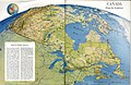 Canada from the southeast, 1952.jpg 2,070 × 1,353; 576 KB
-
 Chile, 1938.jpg 2,168 × 1,434; 668 KB
-
 China seen from the direction of Guam, 1941.jpg 5,740 × 3,594; 6.92 MB
-
 Europe as viewed from the USSR, 1944.jpg 5,327 × 4,011; 6.17 MB
-
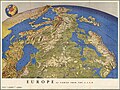
 Europe from the southwest, 1944.jpg 5,496 × 3,487; 2.66 MB
-
 Europe's oil is in danger, 1951.jpg 3,078 × 1,953; 915 KB
-
 Eyes east toward Europe, 1940.jpg 2,913 × 1,934; 787 KB
-
 Japan from China, 1944.jpg 5,500 × 3,484; 3.01 MB
-
 Japan from the Solomons, 1944.jpg 5,495 × 3,496; 3.22 MB
-
 Japan to Alaska, 1944.jpg 5,492 × 3,477; 2.87 MB
-
 One World, One war (1944).jpg 5,501 × 3,492; 2.55 MB
-
 Pacific arena, 1942.jpg 6,094 × 4,879; 6.31 MB
-
 Peru, 1938.jpg 2,783 × 3,558; 3.45 MB
-
 Puerto Rico, 1941.jpg 1,881 × 1,077; 503 KB
-
 South America in globular perspective, 1937.jpg 5,144 × 6,350; 7.65 MB
-
 The Great Hemisphere Highway, 1941.jpg 3,512 × 2,158; 2.26 MB
-
 The joint problem, 1940.jpg 1,652 × 2,065; 611 KB
-
 The newly discovered world beneath the waves, 1959.jpg 6,187 × 3,969; 3.1 MB
-
 The U.S. commitment, 1952.jpg 4,276 × 3,332; 4.93 MB
-
 The World divided, 1941.jpg 5,646 × 3,579; 5.85 MB
-
 Three approaches to the United States, 1940.jpg 4,630 × 5,769; 5.44 MB
-
 USSR, 1941.jpg 5,710 × 3,602; 7.13 MB
-
 Venezuela viewed from the north-northeast, 1939.jpg 5,714 × 3,604; 6.86 MB
-
 World Island, 1944.jpg 5,136 × 3,283; 2.52 MB

.jpg)


.jpg)


