Category:Maps from Meyers Konversationslexikon
Alphabetically sorted by original title.
- ~ .. titel unknown
Subcategories
This category has only the following subcategory.
#
Media in category "Maps from Meyers Konversationslexikon"
The following 78 files are in this category, out of 78 total.
-
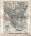 1846 map - Europaeische Türkey, Griechenland und die Ionischen Inseln.tif 5,398 × 6,323; 80.02 MB
-
 1894 Genoa map from Meyers 5th ed.jpg 3,307 × 2,539; 8.75 MB
-
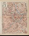 1905-Wien-Meyers.jpg 3,834 × 4,845; 2.63 MB
-
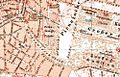
 LA2-Blitz-0021.jpg 2,816 × 3,659; 2.7 MB
-
 Amsterdam kaart Meyers Großes Konversations-Lexikon 1905.jpg 3,359 × 2,094; 3.38 MB
-
 Antwerp, map 1906.jpg 1,024 × 663; 267 KB
-

-
 Asien Bd1.jpg 2,500 × 1,974; 1.96 MB
-
 Map of Asia from 1932 Meyers Konversationslexikon.jpg 3,114 × 2,512; 2.36 MB
-
 Berlin 1905 Meyers Konversationslexikon 6. Auflage.jpg 9,488 × 7,192; 37.64 MB
-
 Berlin 1905 Meyers Konversationslexikon 6. Auflage; Berlin-Reinickendorf (cropped).jpg 1,948 × 1,261; 1.38 MB
-
 Berlin Innere Stadt Meyers großes Konversationslexikon 6. Auflage 1903.jpg 5,000 × 3,838; 6.64 MB
-
 Berlin Innere Stadt Meyers großes Konversationslexikon 6. Auflage 1905.jpg 4,422 × 3,461; 8.15 MB
-
 Berlin Innere Stadt Meyers kleines Konversationslexikon 7. Auflage 1908.jpg 4,008 × 3,196; 9.19 MB
-
 Berlin Innere Stadt Meyers Konversationslexikon ca1910.jpg 1,551 × 1,254; 1.88 MB
-
 Berlin Innere Stadt Meyers Konversationslexikon ca1925.jpg 1,573 × 1,242; 1.51 MB
-
 Karte Boettcherberg.JPG 359 × 289; 42 KB
-
 Bremen-Meyers-1905.jpg 3,518 × 4,268; 2.76 MB
-
 Breslau Meyers6-Wm03394a.jpg 4,435 × 3,539; 6.97 MB
-
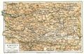 Carinthia.jpg 2,607 × 1,670; 1.14 MB
-
 Deutsches Kaiserreich 1893.jpg 3,049 × 2,411; 1.71 MB
-
 Karte Deutsches Reich 1892.jpg 2,500 × 2,025; 2.44 MB
-
 LA2-Blitz-0083.jpg 3,634 × 2,793; 3.06 MB
-
 Blüherpark 1895.JPG 999 × 640; 160 KB
-
 Brücken westlich Hauptbahnhof Dresden 1895.jpg 517 × 409; 71 KB
-
 Dresden Antonstadt 1895.png 1,044 × 804; 1.18 MB
-
 Dresden Map 1895.jpg 2,938 × 3,758; 2.77 MB
-
 Ostbahnstraße Dresden.jpg 665 × 305; 94 KB
-
 Eisenbahnkarte Deutschland 1908-Wm05514a.jpg 5,732 × 4,488; 10.15 MB
-
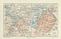
 LA2-Blitz-0103.jpg 2,832 × 1,832; 1.39 MB
-
 LA2-Blitz-0116.jpg 3,622 × 2,797; 2.58 MB
-
 Tibet and India map detail, from- LA2-Blitz-0103 (cropped).jpg 353 × 274; 46 KB
-
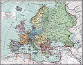 Europa 1890.jpg 2,500 × 1,956; 1.84 MB
-
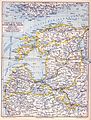 Meyerbaltikum.jpg 1,513 × 2,000; 1.26 MB
-
 Frankfurt Altstadt-Position-Alte Boerse.jpg 1,600 × 1,021; 1.1 MB
-
 Frankfurt Altstadt-Position-Fuersteneck.jpg 1,600 × 1,021; 1.07 MB
-
 Frankfurt Altstadt-Position-Grosser Engel.jpg 1,600 × 1,021; 815 KB
-
 Frankfurt Altstadt-Position-Grosser Speicher.jpg 1,600 × 1,021; 1.1 MB
-
 Frankfurt Altstadt-Position-Hof Rebstock am Markt.jpg 1,600 × 1,021; 1.08 MB
-
 Frankfurt Altstadt-Position-Neues Rotes Haus am Markt.jpg 1,600 × 1,021; 1.1 MB
-
 Frankfurt Altstadt-Position-Salzhaus.jpg 1,600 × 1,021; 911 KB
-
 Frankfurt Altstadt-Position-Scharnhaeuser.jpg 1,600 × 1,021; 796 KB
-
 Frankfurt Altstadt-Position-Stadtwaage.jpg 1,600 × 1,021; 1.08 MB
-
 Frankfurt Am Main-Schopenhauerhaus-Position-Meyers.jpg 1,600 × 1,021; 1.07 MB
-
 Frankfurt Am Main-Weidenhof-Position-Meyers.jpg 1,600 × 1,021; 1.03 MB
-
 Hamburg 1898 Meyers 5. Aufl..jpg 3,176 × 2,480; 7.3 MB
-
 Hamburg 1905 Meyers 6. Aufl..jpg 3,193 × 2,479; 7.88 MB
-

-

-
 Hannover Stadtplan 1895 Meyers Konversations-Lexikon 5. Auflage Band 8 Seite 350a2.jpg 4,252 × 5,476; 25.57 MB
-
 Hannover Stadtplan 1895 Meyers Konversations-Lexikon 5. Auflage Band 8 Seite 350a3.jpg 3,908 × 5,873; 14.09 MB
-
 Hinter-Indien, 1876.jpg 4,200 × 5,265; 12.4 MB
-
 LA2-Blitz-0298p.png 762 × 282; 396 KB
-
 Leipzig Stadtplan mit Umgebung 1892-1898.jpg 2,523 × 3,150; 1.52 MB
-
 Mainz und Kastel Zeno6.Aufl Wm13132a.jpg 3,503 × 2,240; 1.57 MB
-
 Map of Cape Peninsula, Meyer 5th. Edition, 1896.jpg 1,583 × 3,751; 1.75 MB
-
 Meyers b6 s0497a.jpg 3,231 × 2,599; 8.94 MB
-
 Meyers Konversationslexikon - Karte München 1906.jpg 1,428 × 1,171; 2.07 MB
-
 LA2-Blitz-0289.jpg 2,799 × 3,623; 2.6 MB
-
 LA2-Blitz-0298.jpg 3,648 × 2,796; 2.28 MB
-
 Reichstagswahlkarte 1893-1898.jpg 2,172 × 1,720; 2.99 MB
-
 Reichstagswahlkarte 1898-1903.jpg 2,161 × 1,709; 2.74 MB
-
 Schleswig-Holstein 1909 Mayers Kon Lex.jpg 4,977 × 6,229; 21.78 MB
-

-
 Stadtplan Hannover 1895 Meyers Konversations-Lexikon 5. Auflage 200dpi.jpg 1,623 × 1,975; 3.81 MB
-
 Steiermark Karte Meyers Konversations-Lexikon 5 Auflage Stand ca 1899.jpg 14,339 × 11,464; 187.42 MB
-
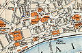
 Stadtplan-Stuttgart-1893.jpg 994 × 626; 272 KB
-
 LA2-Blitz-0379.jpg 2,816 × 3,695; 3 MB
-
 Uetersen 1909 Mayers Kon Lex.jpg 851 × 664; 377 KB
-
 Umgebung von Berlin Meyers Konversationslexikon 1892.jpg 4,216 × 3,359; 8.31 MB
-
 Umgebung von Berlin Meyers Konversationslexikon 1894.jpg 3,200 × 2,500; 5.22 MB
-
 Dresden suburbs 1895.jpg 2,598 × 1,648; 1.16 MB
-
 Verbreitung der Juden im deutschen Reich.jpg 3,513 × 2,554; 1.62 MB
-
 Verbreitung der Konfessionen im deutschen Reich.jpg 3,160 × 2,547; 6.69 MB
-
 Wiesbaden Zeno6.Aufl.-Wm20614a.jpg 3,473 × 4,223; 6.39 MB
-
 Wilhelmshaven Wm20644a.jpg 3,547 × 2,146; 1.56 MB
-
 Würzburg Meyers6-Wm20792a.jpg 3,254 × 2,183; 1.62 MB
-
 Karte Orangerie.jpg 416 × 308; 54 KB


.jpg)


.jpg)


.jpg)


