Category:Maps from the Collection d'Anville
Media in category "Maps from the Collection d'Anville"
The following 14 files are in this category, out of 14 total.
-
 Plan de Paris 1383 BNF07710748.png 1,984 × 1,616; 4.75 MB
-
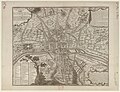
 Plan de Paris 1589-1643 BNF07710699.png 3,868 × 3,169; 15.75 MB
-
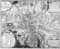
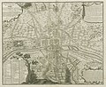
 Plan de Paris 1705 BNF07710700.png 3,890 × 3,158; 15.89 MB
-
 Plan de Paris 1180 BNF07710746.png 1,932 × 1,568; 4.38 MB
-
 Plan de Paris 1223 BNF07710747 - Gallica.jpg 8,568 × 7,069; 49.93 MB
-
 Plan de Paris 1223 BNF07710747.png 1,964 × 1,616; 2.5 MB
-
 Plan de Paris 1422 1589 BNF07710749.png 2,016 × 1,676; 5.25 MB
-
 Plan de Paris Lutece - La boite verte.png 2,577 × 2,048; 5.77 MB
-
 Plan de Paris Lutece BNF07710744.png 2,064 × 1,684; 5.01 MB
-
 Plan de Paris Lutece2 BNF07710745.png 2,020 × 1,656; 4.98 MB
-
 Plan manuscrit du domaine de Versailles et de ses environs - Gallica 2013 (adjusted).jpg 20,502 × 18,299; 39.74 MB
-
 Plan manuscrit du domaine de Versailles et de ses environs - Gallica 2013.jpg 21,084 × 18,609; 71.3 MB
-
 Quatrième plan de la ville de Paris - Gallica 1.jpg 10,447 × 8,014; 27.63 MB
-
 Quatrième plan de la ville de Paris - Gallica 2.jpg 6,644 × 5,444; 6.31 MB


.jpg)


