Category:Maps of 18th-century Africa
English: Modern maps showing the history of Africa. Not to be confused with genuinely old 18th-century maps of Africa
Subcategories
This category has only the following subcategory.
M
- Maps of the Alaouite Sultanate (12 F)
Media in category "Maps of 18th-century Africa"
The following 15 files are in this category, out of 15 total.
-
 Af.Est 1700.png 1,720 × 1,830; 638 KB
-
 Africa 1797, Franz Ludwig Güssefeld (4017888-recto) cropped.jpg 1,534 × 1,376; 1.23 MB
-
 Africa 1797, Franz Ludwig Güssefeld (4017888-recto).png 3,751 × 3,174; 19.99 MB
-
 Africa de l'Oèst (fin sègle XVIII).png 1,192 × 592; 172 KB
-
 Campagnes d'Osei Tutu bis.jpg 654 × 753; 95 KB
-
 Campagnes Osei tutu + distance.jpg 660 × 750; 99 KB
-
 Congo a la fin dau sègle XVIII.png 684 × 619; 158 KB
-
 Empire of Oman.png 2,700 × 3,264; 3.79 MB
-
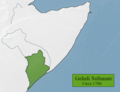 Geledi Sultanate.png 641 × 493; 119 KB
-
 Hiraab Imamate.png 641 × 493; 118 KB
-
 Kabylestatesp.png 1,544 × 856; 399 KB
-
 Majeerteen Sultanate.png 641 × 493; 113 KB
-
 Nigèria - Situacion politica vèrs la fin dau sègle XVIII.png 838 × 527; 140 KB
-
 Omani Empire 2.png 4,645 × 4,399; 2.21 MB
-
 Warsangali Sultanate map.png 641 × 493; 115 KB

_cropped.jpg)
.png)
.png)


