Category:Maps of Bay Ridge, Brooklyn
Media in category "Maps of Bay Ridge, Brooklyn"
The following 19 files are in this category, out of 19 total.
-

-

-

-

-
 2012 NY-11 election results.svg 800 × 529; 12 KB
-
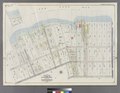
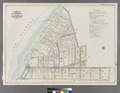
 Bayridge. Town of New Utrecht, Kings Co. NYPL1527267.tiff 7,230 × 5,428; 112.31 MB
-

-
-

-
-

-
 New York District 13 109th US Congress.png 709 × 398; 29 KB
-
 New York US Congressional District 11 (since 2013).tif 2,130 × 1,008; 3.49 MB
-
 New York's 11th congressional district (new version) (since 2025).svg 1,600 × 1,067; 1.52 MB
-
 NewYorkCongD11(2016).svg 800 × 450; 33 KB
-
 NewYorkCongD11(2020).svg 800 × 450; 33 KB
-

-
 New York State Senate District 22 (2012).png 2,740 × 2,480; 541 KB
-
 New York State Senate District 23 (2012).png 2,740 × 2,480; 542 KB

.jpg)
_-_Kings_County_-_Brooklyn_-_ED_24-1_to_3802_-_NARA_-_24267303_(page_6).jpg)


_(since_2025).svg)
.svg)
.svg)
.png)
.png)