Category:Maps of Caernarfonshire
Wikimedia category | |||||
| Upload media | |||||
| Instance of | |||||
|---|---|---|---|---|---|
| Category combines topics | |||||
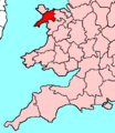
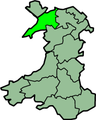
| Caernarfonshire | |||||
historic county of Wales    | |||||
| Instance of | |||||
| Named after | |||||
| Location | Wales | ||||
| Capital | |||||
| Inception |
| ||||
| Population |
| ||||
 | |||||

Subcategories
This category has the following 5 subcategories, out of 5 total.
Media in category "Maps of Caernarfonshire"
The following 18 files are in this category, out of 18 total.
-
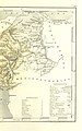
 102 of 'England and Wales Delineated, etc' (11034650334).jpg 1,519 × 2,431; 803 KB
-
 103 of 'England and Wales Delineated, etc' (11033082715).jpg 1,519 × 2,431; 807 KB
-
 Admiralty Chart No 1464 Menai Strait Wales, Published 1894.jpg 8,192 × 12,112; 20.53 MB
-
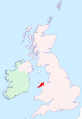 Caernarfonshire - British Isles.svg 1,260 × 1,835; 942 KB
-
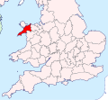
 Caernarfonshire Brit Isles Sect 3.svg 939 × 677; 940 KB
-
 Caernarfonshire Brit Isles Sect 4.svg 627 × 643; 938 KB
-
 Caernarfonshire Brit Isles Sect 5.svg 809 × 743; 939 KB
-
 Caernarfonshire Brit Isles Sect 6.svg 545 × 593; 938 KB
-
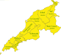 Caernarfonshire Hundreds.svg 1,366 × 1,235; 698 KB
-
 CaernarfonshireBrit6.PNG 398 × 459; 11 KB
-
 Ordnance Survey half-inch sheet Snowdonia National Park, published 1966.jpg 13,105 × 16,591; 19.6 MB
-
 Ordnance Survey One-Inch Sheet 106 Anglesey, Published 1962.jpg 8,259 × 9,918; 9.26 MB
-
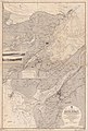
 Ordnance Survey One-Inch Sheet 107 Snowdon, Published 1947.jpg 8,246 × 9,572; 11.69 MB
-
 Ordnance Survey One-Inch Sheet 107 Snowdon, Published 1953.jpg 8,359 × 9,967; 11.85 MB
-
 Ordnance Survey One-Inch Sheet 107 Snowdon, Published 1962.jpg 8,217 × 9,865; 12.28 MB
-
 Snowdon and its surroundings.jpg 12,329 × 8,737; 24.29 MB
-
 Snowdonia National Park map.svg 1,025 × 1,305; 1.13 MB
-
 WalesCaernarfonshireTrad.png 200 × 250; 24 KB
.jpg)
.jpg)


