Category:Maps of Candia by Ortelius and Mercator
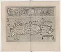
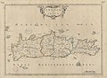
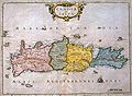
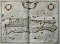
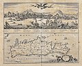
The map design for Candia Insula, typical for the exaggerated bay seperating the promontory, was apparently created by Abraham Ortelius in 1584, and then used both by him and and Gerhard Mercator for their geographical atlases. Because of the popularity of these atlases and their recurring reprints and copies by other cartographers/geographers, this coastal outline for Crete was still used near the end of the 17th century.
Where possible, please use the publishing dates as keys, and name the cartographers/publishers.
Media in category "Maps of Candia by Ortelius and Mercator"
The following 36 files are in this category, out of 36 total.
-

-
 Candia Insula - (par Abraham Ortelius) - btv1b530116864.jpg 6,011 × 2,212; 2.94 MB
-

-

-

-
 Atlas Cosmographicae (Mercator) 275.jpg 2,812 × 2,032; 2.12 MB
-
 Gerardus Mercator, Candia cum Insulis aliquot circa Græciam (FL35076755 2565127).jpg 12,396 × 10,567; 197.76 MB
-

-

-
 Atlas Minor Gerardi Mercatoris 1609 (106757466).jpg 6,005 × 4,675; 5.97 MB
-
-

-
 Gerardus Mercator, Candia cum Insulis aliquot circa Græciam (FL35071224 2530807).jpg 13,025 × 10,919; 203.99 MB
-

-
 Cosmographicae (10534319).jpg 12,101 × 8,166; 31.06 MB
-

-
 Atlas ou Representation du Monde Universel t. 2. 1633 (110102784).jpg 16,970 × 11,842; 34.93 MB
-

-

-
 Candia olim Creta - btv1b53194577k (2 of 5).jpg 8,680 × 6,485; 8.11 MB
-
 Candia olim Creta - (Abraham) Peyrounin sculp(sit) - btv1b530115179.jpg 6,622 × 4,882; 4.46 MB
-
 Venetiancrete.jpg 800 × 585; 186 KB
-
 Candia olim Creta - A. Peyrounin sculp - btv1b59719749.jpg 6,486 × 4,758; 2.69 MB
-

-
 "Candia, olim Creta." (22065732509).jpg 4,248 × 3,108; 1.81 MB
-

-
 Candia (BM 1882,0211.86).jpg 2,500 × 2,054; 1.26 MB
-
 Map - Special Collections University of Amsterdam - OTM- HB-KZL 33.08.13.tif 7,320 × 6,187; 129.57 MB
-
 Insula Candia olim Creta (with View of Candia).jpg 750 × 612; 178 KB
-
 Map - Special Collections University of Amsterdam - OTM- HB-KZL 33.08.18.tif 7,200 × 6,033; 124.28 MB
-
 MapaCreta.jpg 700 × 578; 142 KB
-
 Insula Candia (8343734844).jpg 6,779 × 5,556; 38.97 MB
-

-
 Atlas Van der Hagen-KW1049B12 098 2-INSULA CANDIA olim CRETA.jpeg 5,500 × 2,277; 1.95 MB
-
 Insula Candia olim Creta - CBT 5883819.jpg 5,728 × 4,646; 9.55 MB
-
 UBBasel Map 1600-1699 Kartenslg Mappe 250-37 Candia Creta.tiff 8,492 × 2,785, 2 pages; 67.69 MB
_and_10_Greek_Islands_-_Geographicus_-_CandiaInsula-ortelius-1584.jpg)
.jpg)
.jpg)
_275.jpg)
.jpg)
.jpg)

.jpg)
_-_btv1b53096740c_(486_of_603).jpg)
.jpg)
.jpg)
.jpg)
.jpg)
.jpg)
.jpg)
.jpg)
.jpg)
.jpg)
_Peyrounin_sculp(sit)_-_btv1b530115179.jpg)


_-_btv1b52511195b_(49_of_85).jpg)
.jpg)
.2.(37).jpg)
.jpg)
.jpg)

.jpg)


_-_btv1b530116864.jpg)
_and_10_Greek_Islands_-_Geographicus_-_CandiaInsula-ortelius-1584_(cropped).jpg)