Category:Maps of Goa by Braun & Hogenberg
Latina: Goa fortissima Indiae urbs in Christianorum potestatem anno Salutis 1509 devenit.
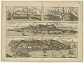
English: Hogenberg's map of Goa shows the place Telonium, the secured places of Benesterÿ, Pangura (Panaji?) and Nuradoÿro around the main city on the isle of Goa, Momizquita on Fanū Indorum (Divar?). Neither of these place names can be found on current maps of Goa. Nuradoÿro is under fire by European ships. The main title says Goa fortißima Indiæ vrbs in Christianorum potestatem anno Salutis 1509 deuenit. (translation: Goa, fortified Indian city, submitted under Christian might in the year of the Lord 1509.)
Deutsch: Hogenbergs Karte von Goa zeigt den Ort Telonium, die bewehrten Orte Benesterÿ, Pangura und Nuradoÿro rund um die Stadt auf der Insel Goa, Momizquita auf Fanū Indorum. Nuradoÿro liegt unter Beschuss durch europäische Schiffe. Der Titel lautet Goa fortißima Indiæ vrbs in Christianorum potestatem anno Salutis 1509 deuenit. (übersetzt: Goa, befestigte indische Stadt, fiel unter christliche Herrschaft im Jahre des Herrn 1509.)
Media in category "Maps of Goa by Braun & Hogenberg"
The following 15 files are in this category, out of 15 total.
-
 Anfa, quibusdam Anaffa ; Azaamurum ; Diu - btv1b53178870b (1 of 2).jpg 6,476 × 4,922; 4.68 MB
-
 Beschreibung der Städt der Welt - Braun & Hogenberg - btv1b52512111k (181 of 378).jpg 8,240 × 6,331; 7.34 MB
-
-

-

-

-

-
 Frans Hogenberg, Anfa (FL43900280 3943379).jpg 13,866 × 9,912; 199.45 MB
-

-
 Braun Goa HAAB.jpg 1,163 × 343; 271 KB
-
 Braun Goa UBHD.jpg 2,049 × 643; 770 KB
-
 Goa Braun Hogenberg.jpg 7,751 × 2,330; 1.77 MB
-
 Probably the earliest depiction of Goa, from 1572 1.jpg 1,200 × 374; 78 KB
-
 Probably the earliest depiction of Goa.jpg 5,059 × 1,576; 744 KB
-
 Civitates orbis terrarvm, liber primvs 1577 (107275192).jpg 15,719 × 10,876; 27.66 MB
.jpg)
.jpg)


.jpg)
.jpg)
.jpg)